Zuolong geodata
Zuolong (Jiangxi) is a seat of a fourth-order administrative division; located in China in Asia/Shanghai (GMT+8) time zone. In our database, there are 1268 cities with bigger population. Compared to other cities in China, 77.4% of cities are located further ↑North; 56.5% of cities are located further ←West and 65.6% of cities have higher elevation than Zuolong. Note1


Zuolong GPS coordinates[2]
27° 18' 49.968" North, 115° 24' 32.508" East
| Map corner | latitude | longitude |
|---|---|---|
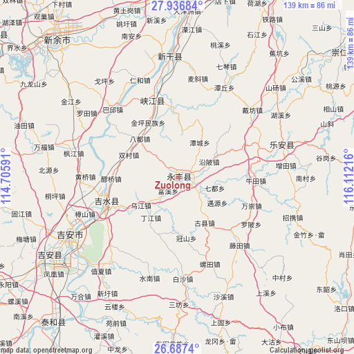
| Upper-left | 27.93684°, | 114.70591° |
| Center: | 27.31388°, | 115.40903° |
| Lower-right: | 26.6874°, | 116.11216° |
| Map W x H: | 138.9×138.9 km | = 86.3×86.3mi |
| max Lat: | 53.31946° ⇑77.4% North |
| Zuolong: | 27.31388° |
| min Lat: | ⇓22.6% South 18.22056° |
| min Long | Zuolong | max Long |
| 75.07348° | 115.40903° | 134.28917° |
| W 56.5%⇐ | ⇒43.5% E |
Elevation
Elevation of Zuolong is 70 m = 230 ft, and this is 414.8 m = 1361 ft below average elevation for this country.
| Max E: |
5622 m = 18445 ft | 65.6% |
| Avg. | 484.8 m = 1591 ft | |
| Zuolong | 70 m = 230 ft | |
Min E: |
-3 m = -10 ft | 34.4% |
See also: China elevation on elevation.city.
Geographical zone
Zuolong is located in North temperate zone (between Tropic of Cancer and the Arctic Circle). Distance of this Northern Tropic circle is 431.1 km =267.9 mi to South.| Distance of | km | miles | from Zuolong |
|---|---|---|---|
| North Pole | 6970 | 4331 | to North |
| Arctic Circle | 4364.2 | 2711.8 | to North |
| Tropic Cancer | 431.1 | 267.9 | to South |
| Equator | 3037 | 1887.1 | to South |


Nearby cities:
15 places around Zuolong: (largest is in red/bold)
• Badu
21.3 km =13.2 mi,  316°
316°
• Bajiang
13.5 km =8.4 mi,  204°
204°
• Dingjiang
19.2 km =11.9 mi,  213°
213°
• Enjiang
2.2 km =1.4 mi,  66°
66°
• Guanshan
24.1 km =15 mi,  171°
171°
• Guxian
20.7 km =12.9 mi,  149°
149°
• Kengtian
4.6 km =2.9 mi, 319°
• Laoqiao
26.4 km =16.4 mi,  267°
267°
• Lugang
23 km =14.3 mi,  63°
63°
• Qidu
15.2 km =9.4 mi,  106°
106°
• Shuangcun
20.8 km =12.9 mi,  295°
295°
• Tancheng
16.3 km =10.1 mi,  32°
32°
• Tonglin
22.1 km =13.7 mi,  2°
2°
• Wujiang
18.1 km =11.2 mi,  232°
232°
• Yanbei
13.7 km =8.5 mi, 62°
Sources, notices
• [Note1] Compared only with cities in China existing in our database
• [Src1] Map data: © OpenStreetMap contributors (CC-BY-SA)
• [Src2] Other city data from geonames.org with taken over terms of usage.
• [Src3] Geographical zone / Annual Mean Temperature by Robert A. Rohde @ Wikipedia
