Huanghuatang geodata
Huanghuatang (Jiangsu) is a seat of a fourth-order administrative division; located in China in Asia/Shanghai (GMT+8) time zone. In our database, there are 1268 cities with bigger population. Compared to other cities in China, 65.6% of cities are located further ↓South; 74.9% of cities are located further ←West and 74.1% of cities have higher elevation than Huanghuatang. Note1


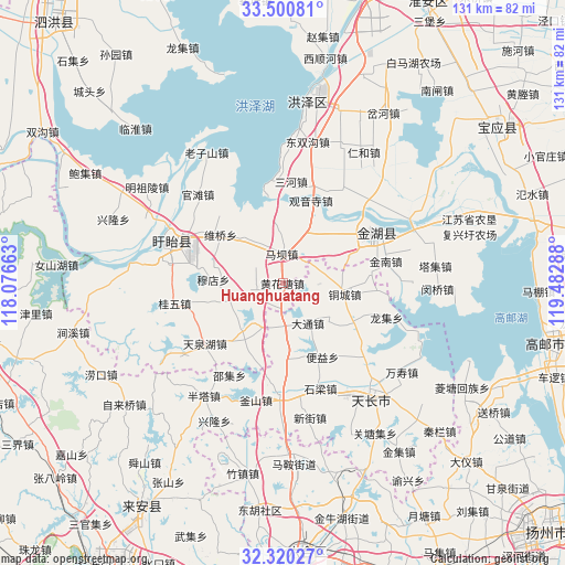
Huanghuatang GPS coordinates[2]
32° 54' 45.036" North, 118° 46' 47.1" East
| Map corner | latitude | longitude |
|---|---|---|
| Upper-left | 33.50081°, | 118.07663° |
| Center: | 32.91251°, | 118.77975° |
| Lower-right: | 32.32027°, | 119.48288° |
| Map W x H: | 131.3×131.3 km | = 81.6×81.6mi |
| max Lat: | 53.31946° ⇑34.4% North |
| Huanghuatang: | 32.91251° |
| min Lat: | ⇓65.6% South 18.22056° |
| min Long | Huanghuatang | max Long |
| 75.07348° | 118.77975° | 134.28917° |
| W 74.9%⇐ | ⇒25.1% E |
Elevation
Elevation of Huanghuatang is 39 m = 128 ft, and this is 445.8 m = 1463 ft below average elevation for this country.
| Max E: |
5622 m = 18445 ft | 74.1% |
| Avg. | 484.8 m = 1591 ft | |
| Huanghuatang | 39 m = 128 ft | |
Min E: |
-3 m = -10 ft | 25.9% |
See also: China elevation on elevation.city.
Geographical zone
Huanghuatang is located in North temperate zone (between Tropic of Cancer and the Arctic Circle). Distance of this Northern Tropic circle is 1053.6 km =654.7 mi to South.| Distance of | km | miles | from Huanghuatang |
|---|---|---|---|
| North Pole | 6347.5 | 3944.2 | to North |
| Arctic Circle | 3741.6 | 2324.9 | to North |
| Tropic Cancer | 1053.6 | 654.7 | to South |
| Equator | 3659.5 | 2273.9 | to South |


Nearby cities:
15 places around Huanghuatang: (largest is in red/bold)
• Anle
8.7 km =5.4 mi,  88°
88°
• Chajian
26.2 km =16.3 mi,  182°
182°
• Datong
11.2 km =7 mi,  147°
147°
• Gaomiaoji
20.4 km =12.7 mi,  84°
84°
• Guiwu
25.7 km =16 mi,  259°
259°
• Gusang
26.1 km =16.2 mi,  281°
281°
• Jinnan
24.7 km =15.3 mi, 78°
• Jiupu
14.5 km =9 mi,  221°
221°
• Maba
7.5 km =4.7 mi,  0°
0°
• Mudian
16.1 km =10 mi,  272°
272°
• Shiliang
26.1 km =16.2 mi,  160°
160°
• Tongcheng
14.3 km =8.9 mi,  96°
96°
• Wangdian
22.7 km =14.1 mi,  233°
233°
• Yangcun
22.9 km =14.2 mi,  126°
126°
• Zhangpu
16.9 km =10.5 mi, 178°
Sources, notices
• [Note1] Compared only with cities in China existing in our database
• [Src1] Map data: © OpenStreetMap contributors (CC-BY-SA)
• [Src2] Other city data from geonames.org with taken over terms of usage.
• [Src3] Geographical zone / Annual Mean Temperature by Robert A. Rohde @ Wikipedia
