Gaomiaoji geodata
Gaomiaoji (Anhui) is a seat of a fourth-order administrative division; located in China in Asia/Shanghai (GMT+8) time zone. In our database, there are 1268 cities with bigger population. Compared to other cities in China, 65.7% of cities are located further ↓South; 76% of cities are located further ←West and 80.8% of cities have higher elevation than Gaomiaoji. Note1


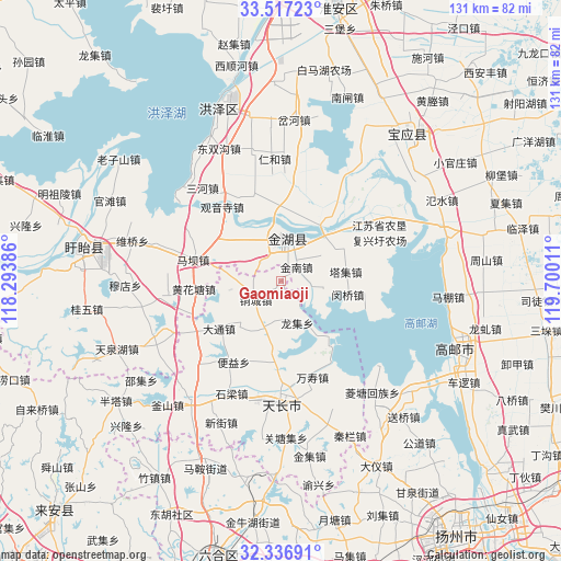
Gaomiaoji GPS coordinates[2]
32° 55' 44.544" North, 118° 59' 49.128" East
| Map corner | latitude | longitude |
|---|---|---|
| Upper-left | 33.51723°, | 118.29386° |
| Center: | 32.92904°, | 118.99698° |
| Lower-right: | 32.33691°, | 119.70011° |
| Map W x H: | 131.2×131.2 km | = 81.5×81.5mi |
| max Lat: | 53.31946° ⇑34.3% North |
| Gaomiaoji: | 32.92904° |
| min Lat: | ⇓65.7% South 18.22056° |
| min Long | Gaomiaoji | max Long |
| 75.07348° | 118.99698° | 134.28917° |
| W 76%⇐ | ⇒24% E |
Elevation
Elevation of Gaomiaoji is 25 m = 82 ft, and this is 459.8 m = 1509 ft below average elevation for this country.
| Max E: |
5622 m = 18445 ft | 80.8% |
| Avg. | 484.8 m = 1591 ft | |
| Gaomiaoji | 25 m = 82 ft | |
Min E: |
-3 m = -10 ft | 19.2% |
See also: China elevation on elevation.city.
Geographical zone
Gaomiaoji is located in North temperate zone (between Tropic of Cancer and the Arctic Circle). Distance of this Northern Tropic circle is 1055.4 km =655.8 mi to South.| Distance of | km | miles | from Gaomiaoji |
|---|---|---|---|
| North Pole | 6345.7 | 3943 | to North |
| Arctic Circle | 3739.8 | 2323.8 | to North |
| Tropic Cancer | 1055.4 | 655.8 | to South |
| Equator | 3661.4 | 2275.1 | to South |


Nearby cities:
15 places around Gaomiaoji: (largest is in red/bold)
• Anle
11.7 km =7.3 mi,  262°
262°
• Datong
18.1 km =11.2 mi,  231°
231°
• Huanghuatang
20.4 km =12.7 mi, 264°
• Jiepai
29.5 km =18.3 mi,  150°
150°
• Jinnan
4.9 km =3 mi,  53°
53°
• Maba
21 km =13 mi,  285°
285°
• Minqiao
16.1 km =10 mi,  100°
100°
• Shiliang
28.8 km =17.9 mi,  203°
203°
• Taji
15.2 km =9.4 mi,  81°
81°
• Tianchang
27.2 km =16.9 mi,  177°
177°
• Tongcheng
6.9 km =4.3 mi,  240°
240°
• Wanshou
23.8 km =14.8 mi,  161°
161°
• Yangcun
15.5 km =9.6 mi,  186°
186°
• Yongfeng
22 km =13.7 mi, 181°
• Zhangpu
27.3 km =17 mi, 226°
Sources, notices
• [Note1] Compared only with cities in China existing in our database
• [Src1] Map data: © OpenStreetMap contributors (CC-BY-SA)
• [Src2] Other city data from geonames.org with taken over terms of usage.
• [Src3] Geographical zone / Annual Mean Temperature by Robert A. Rohde @ Wikipedia
