Xibei geodata
Xibei (Jiangsu) is a seat of a fourth-order administrative division; located in China in Asia/Shanghai (GMT+8) time zone. In our database, there are 1268 cities with bigger population. Compared to other cities in China, 59.3% of cities are located further ↓South; 84.7% of cities are located further ←West and 95.9% of cities have higher elevation than Xibei. Note1


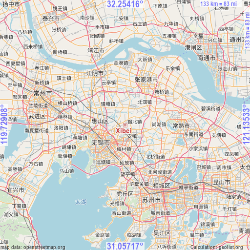
Xibei GPS coordinates[2]
31° 39' 27.324" North, 120° 25' 55.92" East
| Map corner | latitude | longitude |
|---|---|---|
| Upper-left | 32.25416°, | 119.72908° |
| Center: | 31.65759°, | 120.4322° |
| Lower-right: | 31.05717°, | 121.13533° |
| Map W x H: | 133.1×133.1 km | = 82.7×82.7mi |
| max Lat: | 53.31946° ⇑40.7% North |
| Xibei: | 31.65759° |
| min Lat: | ⇓59.3% South 18.22056° |
| min Long | Xibei | max Long |
| 75.07348° | 120.4322° | 134.28917° |
| W 84.7%⇐ | ⇒15.3% E |
Elevation
Elevation of Xibei is 6 m = 20 ft, and this is 478.8 m = 1571 ft below average elevation for this country.
| Max E: |
5622 m = 18445 ft | 95.9% |
| Avg. | 484.8 m = 1591 ft | |
| Xibei | 6 m = 20 ft | |
Min E: |
-3 m = -10 ft | 4.1% |
See also: China elevation on elevation.city.
Geographical zone
Xibei is located in North temperate zone (between Tropic of Cancer and the Arctic Circle). Distance of this Northern Tropic circle is 914.1 km =568 mi to South.| Distance of | km | miles | from Xibei |
|---|---|---|---|
| North Pole | 6487.1 | 4030.9 | to North |
| Arctic Circle | 3881.2 | 2411.7 | to North |
| Tropic Cancer | 914.1 | 568 | to South |
| Equator | 3520 | 2187.2 | to South |


Nearby cities:
15 places around Xibei: (largest is in red/bold)
• Anzhen
6.4 km =4 mi,  145°
145°
• Beidajie
15.7 km =9.8 mi,  239°
239°
• Changjianglu
13.3 km =8.3 mi,  219°
219°
• Changjing
11.7 km =7.3 mi,  21°
21°
• Chong’ansi
15.6 km =9.7 mi, 236°
• Dongbeitang
7.9 km =4.9 mi,  250°
250°
• Fangqian
12.2 km =7.6 mi,  203°
203°
• Gushan
13.8 km =8.6 mi,  52°
52°
• Liutan
13.9 km =8.6 mi, 252°
• Meicun
12.4 km =7.7 mi,  180°
180°
• Wangzhuang
14.8 km =9.2 mi,  212°
212°
• Xuxiake
14.7 km =9.1 mi,  322°
322°
• Yangjian
12 km =7.5 mi,  105°
105°
• Yanqiao
15 km =9.3 mi,  283°
283°
• Zhutang
12.7 km =7.9 mi,  349°
349°
Sources, notices
• [Note1] Compared only with cities in China existing in our database
• [Src1] Map data: © OpenStreetMap contributors (CC-BY-SA)
• [Src2] Other city data from geonames.org with taken over terms of usage.
• [Src3] Geographical zone / Annual Mean Temperature by Robert A. Rohde @ Wikipedia
