Meicun geodata
Meicun (Jiangsu) is a seat of a fourth-order administrative division; located in China in Asia/Shanghai (GMT+8) time zone. In our database, there are 1268 cities with bigger population. Compared to other cities in China, 58.7% of cities are located further ↓South; 84.6% of cities are located further ←West and 88.7% of cities have higher elevation than Meicun. Note1


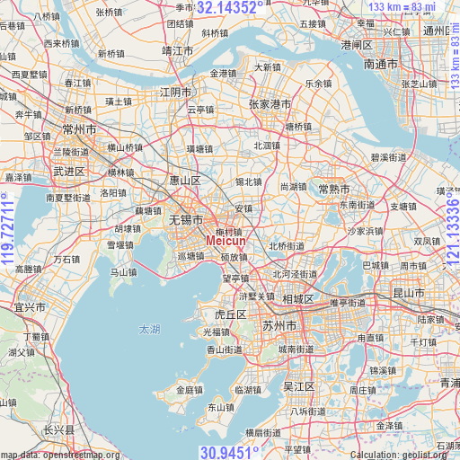
Meicun GPS coordinates[2]
31° 32' 46.428" North, 120° 25' 48.828" East
| Map corner | latitude | longitude |
|---|---|---|
| Upper-left | 32.14352°, | 119.72711° |
| Center: | 31.54623°, | 120.43023° |
| Lower-right: | 30.9451°, | 121.13336° |
| Map W x H: | 133.3×133.3 km | = 82.8×82.8mi |
| max Lat: | 53.31946° ⇑41.3% North |
| Meicun: | 31.54623° |
| min Lat: | ⇓58.7% South 18.22056° |
| min Long | Meicun | max Long |
| 75.07348° | 120.43023° | 134.28917° |
| W 84.6%⇐ | ⇒15.4% E |
Elevation
Elevation of Meicun is 11 m = 36 ft, and this is 473.8 m = 1554 ft below average elevation for this country.
| Max E: |
5622 m = 18445 ft | 88.7% |
| Avg. | 484.8 m = 1591 ft | |
| Meicun | 11 m = 36 ft | |
Min E: |
-3 m = -10 ft | 11.3% |
See also: China elevation on elevation.city.
Geographical zone
Meicun is located in North temperate zone (between Tropic of Cancer and the Arctic Circle). Distance of this Northern Tropic circle is 901.7 km =560.3 mi to South.| Distance of | km | miles | from Meicun |
|---|---|---|---|
| North Pole | 6499.4 | 4038.5 | to North |
| Arctic Circle | 3893.6 | 2419.4 | to North |
| Tropic Cancer | 901.7 | 560.3 | to South |
| Equator | 3507.6 | 2179.5 | to South |


Nearby cities:
15 places around Meicun: (largest is in red/bold)
• Anzhen
8 km =5 mi,  27°
27°
• Changjianglu
8.6 km =5.3 mi,  284°
284°
• Chong’ansi
13.3 km =8.3 mi,  286°
286°
• Dongbeitang
12.1 km =7.5 mi,  323°
323°
• Ehu
10.9 km =6.8 mi,  102°
102°
• Fangqian
4.9 km =3 mi, 284°
• Helie
13.6 km =8.5 mi,  258°
258°
• Hongshan
8.9 km =5.5 mi,  139°
139°
• Huazhuang
10.8 km =6.7 mi,  229°
229°
• Nanchansi
12.5 km =7.8 mi, 278°
• Shuofang
6.5 km =4 mi,  171°
171°
• Wangting
11.8 km =7.3 mi,  175°
175°
• Wangzhuang
7.7 km =4.8 mi,  268°
268°
• Wuxi
13.7 km =8.5 mi, 280°
• Xibei
12.4 km =7.7 mi,  0°
0°
Sources, notices
• [Note1] Compared only with cities in China existing in our database
• [Src1] Map data: © OpenStreetMap contributors (CC-BY-SA)
• [Src2] Other city data from geonames.org with taken over terms of usage.
• [Src3] Geographical zone / Annual Mean Temperature by Robert A. Rohde @ Wikipedia
