Jingyang geodata
Jingyang (Hubei) is a seat of a fourth-order administrative division; located in China in Asia/Shanghai (GMT+8) time zone. In our database, there are 1268 cities with bigger population. Compared to other cities in China, 65.8% of cities are located further ↓South; 72.3% of cities are located further →East and 64.4% of cities have lower elevation than Jingyang. Note1


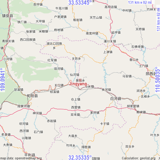
Jingyang GPS coordinates[2]
32° 56' 43.332" North, 109° 47' 49.992" East
| Map corner | latitude | longitude |
|---|---|---|
| Upper-left | 33.53345°, | 109.0941° |
| Center: | 32.94537°, | 109.79722° |
| Lower-right: | 32.35335°, | 110.50035° |
| Map W x H: | 131.2×131.2 km | = 81.5×81.5mi |
| max Lat: | 53.31946° ⇑34.2% North |
| Jingyang: | 32.94537° |
| min Lat: | ⇓65.8% South 18.22056° |
| min Long | Jingyang | max Long |
| 75.07348° | 109.79722° | 134.28917° |
| W 27.7%⇐ | ⇒72.3% E |
Elevation
Elevation of Jingyang is 316 m = 1037 ft, and this is 168.8 m = 554 ft below average elevation for this country.
| Max E: |
5622 m = 18445 ft | 35.6% |
| Avg. | 484.8 m = 1591 ft | |
| Jingyang | 316 m = 1037 ft | |
Min E: |
-3 m = -10 ft | 64.4% |
See also: China elevation on elevation.city.
Geographical zone
Jingyang is located in North temperate zone (between Tropic of Cancer and the Arctic Circle). Distance of this Northern Tropic circle is 1057.3 km =657 mi to South.| Distance of | km | miles | from Jingyang |
|---|---|---|---|
| North Pole | 6343.9 | 3941.9 | to North |
| Arctic Circle | 3738 | 2322.7 | to North |
| Tropic Cancer | 1057.3 | 657 | to South |
| Equator | 3663.2 | 2276.2 | to South |


Nearby cities:
15 places around Jingyang: (largest is in red/bold)
• Baoxia
56.4 km =35 mi,  117°
117°
• Damiao
46.2 km =28.7 mi,  187°
187°
• Desheng
55.1 km =34.2 mi,  175°
175°
• Guanfang
18.4 km =11.4 mi,  349°
349°
• Guanyin
53.5 km =33.2 mi,  95°
95°
• Hubeikou
35.5 km =22.1 mi,  323°
323°
• Hujiaying
46.6 km =29 mi,  113°
113°
• Jiahe
22.6 km =14 mi, 109°
• Jianchi
50.5 km =31.4 mi, 99°
• Ma’an
38.4 km =23.9 mi,  84°
84°
• Qingu
57.8 km =35.9 mi, 177°
• Shangjin
31.6 km =19.6 mi,  45°
45°
• Wufeng
55 km =34.2 mi, 103°
• Yangwei
39.9 km =24.8 mi, 111°
• Zhuping
54.1 km =33.6 mi, 188°
Sources, notices
• [Note1] Compared only with cities in China existing in our database
• [Src1] Map data: © OpenStreetMap contributors (CC-BY-SA)
• [Src2] Other city data from geonames.org with taken over terms of usage.
• [Src3] Geographical zone / Annual Mean Temperature by Robert A. Rohde @ Wikipedia
