Shangjin geodata
Shangjin (Hubei) is a seat of a fourth-order administrative division; located in China in Asia/Shanghai (GMT+8) time zone. In our database, there are 1268 cities with bigger population. Compared to other cities in China, 66.8% of cities are located further ↓South; 71.1% of cities are located further →East and 62.7% of cities have lower elevation than Shangjin. Note1


Shangjin GPS coordinates[2]
33° 8' 37.14" North, 110° 2' 22.632" East
| Map corner | latitude | longitude |
|---|---|---|
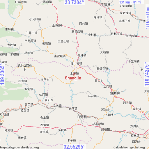
| Upper-left | 33.7304°, | 109.3365° |
| Center: | 33.14365°, | 110.03962° |
| Lower-right: | 32.55295°, | 110.74275° |
| Map W x H: | 130.9×130.9 km | = 81.3×81.3mi |
| max Lat: | 53.31946° ⇑33.2% North |
| Shangjin: | 33.14365° |
| min Lat: | ⇓66.8% South 18.22056° |
| min Long | Shangjin | max Long |
| 75.07348° | 110.03962° | 134.28917° |
| W 28.9%⇐ | ⇒71.1% E |
Elevation
Elevation of Shangjin is 292 m = 958 ft, and this is 192.8 m = 633 ft below average elevation for this country.
| Max E: |
5622 m = 18445 ft | 37.3% |
| Avg. | 484.8 m = 1591 ft | |
| Shangjin | 292 m = 958 ft | |
Min E: |
-3 m = -10 ft | 62.7% |
See also: China elevation on elevation.city.
Geographical zone
Shangjin is located in North temperate zone (between Tropic of Cancer and the Arctic Circle). Distance of this Northern Tropic circle is 1079.3 km =670.6 mi to South.| Distance of | km | miles | from Shangjin |
|---|---|---|---|
| North Pole | 6321.8 | 3928.2 | to North |
| Arctic Circle | 3715.9 | 2309 | to North |
| Tropic Cancer | 1079.3 | 670.6 | to South |
| Equator | 3685.2 | 2289.9 | to South |


Nearby cities:
15 places around Shangjin: (largest is in red/bold)
• Anjia
46 km =28.6 mi,  108°
108°
• Baoxia
55.6 km =34.5 mi,  150°
150°
• Guanfang
26.2 km =16.3 mi,  261°
261°
• Guanyin
40.8 km =25.4 mi,  131°
131°
• Hejia
52.4 km =32.6 mi,  117°
117°
• Hubeikou
44.3 km =27.5 mi,  278°
278°
• Hujiaying
45.1 km =28 mi, 153°
• Jiahe
29.6 km =18.4 mi,  182°
182°
• Jianchi
40.8 km =25.4 mi,  138°
138°
• Jingyang
31.6 km =19.6 mi,  225°
225°
• Ma’an
24.2 km =15 mi, 139°
• Qingqu
62.4 km =38.8 mi, 118°
• Wufeng
46.7 km =29 mi, 138°
• Yangwei
39.4 km =24.5 mi,  158°
158°
• Yunxixian Chengguanzhen
40 km =24.9 mi, 116°
Sources, notices
• [Note1] Compared only with cities in China existing in our database
• [Src1] Map data: © OpenStreetMap contributors (CC-BY-SA)
• [Src2] Other city data from geonames.org with taken over terms of usage.
• [Src3] Geographical zone / Annual Mean Temperature by Robert A. Rohde @ Wikipedia
