Toutai geodata
Toutai (Heilongjiang) is a seat of a fourth-order administrative division; located in China in Asia/Urumqi (GMT+6) time zone. In our database, there are 1268 cities with bigger population. Compared to other cities in China, 93.7% of cities are located further ↓South; 98.7% of cities are located further →East and 64.8% of cities have lower elevation than Toutai. Note1


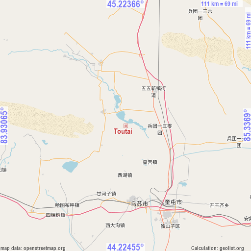
Toutai GPS coordinates[2]
44° 43' 34.536" North, 84° 38' 1.572" East
| Map corner | latitude | longitude |
|---|---|---|
| Upper-left | 45.22366°, | 83.93065° |
| Center: | 44.72626°, | 84.63377° |
| Lower-right: | 44.22455°, | 85.3369° |
| Map W x H: | 111.1×111.1 km | = 69×69mi |
| max Lat: | 53.31946° ⇑6.3% North |
| Toutai: | 44.72626° |
| min Lat: | ⇓93.7% South 18.22056° |
| min Long | Toutai | max Long |
| 75.07348° | 84.63377° | 134.28917° |
| W 1.3%⇐ | ⇒98.7% E |
Elevation
Elevation of Toutai is 322 m = 1056 ft, and this is 162.8 m = 534 ft below average elevation for this country.
| Max E: |
5622 m = 18445 ft | 35.2% |
| Avg. | 484.8 m = 1591 ft | |
| Toutai | 322 m = 1056 ft | |
Min E: |
-3 m = -10 ft | 64.8% |
See also: China elevation on elevation.city.
Geographical zone
Toutai is located in North temperate zone (between Tropic of Cancer and the Arctic Circle). Distance of this Northern Tropic circle is 2367.2 km =1470.9 mi to South.| Distance of | km | miles | from Toutai |
|---|---|---|---|
| North Pole | 5034 | 3128 | to North |
| Arctic Circle | 2428.1 | 1508.8 | to North |
| Tropic Cancer | 2367.2 | 1470.9 | to South |
| Equator | 4973.1 | 3090.1 | to South |


Nearby cities:
15 places around Toutai: (largest is in red/bold)
• Baiquan
41.3 km =25.7 mi,  213°
213°
• Bashisihu
32 km =19.9 mi,  168°
168°
• Dongpaizi
24.2 km =15 mi,  328°
328°
• Dushanzi
46.9 km =29.1 mi,  158°
158°
• Ganhezi
30.7 km =19.1 mi,  195°
195°
• Hatu Buh
43.6 km =27.1 mi,  216°
216°
• Huanggong
19.2 km =11.9 mi,  145°
145°
• Huochezhan
41.4 km =25.7 mi, 149°
• Jiahezi
29.6 km =18.4 mi, 155°
• Jiujianlou
25.9 km =16.1 mi,  142°
142°
• Kuytun
39.4 km =24.5 mi, 147°
• Shiqiao
40.9 km =25.4 mi,  318°
318°
• Usu
33 km =20.5 mi, 174°
• Xidagou
43.7 km =27.2 mi,  185°
185°
• Xihu
21.4 km =13.3 mi,  181°
181°
Sources, notices
• [Note1] Compared only with cities in China existing in our database
• [Src1] Map data: © OpenStreetMap contributors (CC-BY-SA)
• [Src2] Other city data from geonames.org with taken over terms of usage.
• [Src3] Geographical zone / Annual Mean Temperature by Robert A. Rohde @ Wikipedia
