Kuytun geodata
Kuytun (Xinjiang) is a seat of a third-order administrative division; located in China in Asia/Urumqi (GMT+6) time zone. In our database, there are 1268 cities with bigger population. Compared to other cities in China, 93.3% of cities are located further ↓South; 98.6% of cities are located further →East and 73.1% of cities have lower elevation than Kuytun. Note1


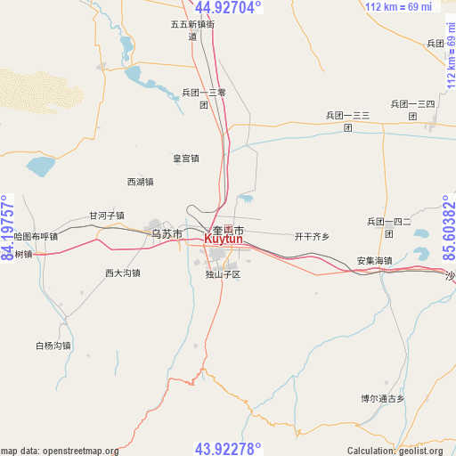
Kuytun GPS coordinates[2]
44° 25' 37.452" North, 84° 54' 2.484" East
| Map corner | latitude | longitude |
|---|---|---|
| Upper-left | 44.92704°, | 84.19757° |
| Center: | 44.42707°, | 84.90069° |
| Lower-right: | 43.92278°, | 85.60382° |
| Map W x H: | 111.7×111.7 km | = 69.4×69.4mi |
| max Lat: | 53.31946° ⇑6.7% North |
| Kuytun: | 44.42707° |
| min Lat: | ⇓93.3% South 18.22056° |
| min Long | Kuytun | max Long |
| 75.07348° | 84.90069° | 134.28917° |
| W 1.4%⇐ | ⇒98.6% E |
Elevation
Elevation of Kuytun is 478 m = 1568 ft, and this is 6.8 m = 22 ft below average elevation for this country.
| Max E: |
5622 m = 18445 ft | 26.9% |
| Avg. | 484.8 m = 1591 ft | |
| Kuytun | 478 m = 1568 ft | |
Min E: |
-3 m = -10 ft | 73.1% |
See also: China elevation on elevation.city.
Geographical zone
Kuytun is located in North temperate zone (between Tropic of Cancer and the Arctic Circle). Distance of this Northern Tropic circle is 2333.9 km =1450.2 mi to South.| Distance of | km | miles | from Kuytun |
|---|---|---|---|
| North Pole | 5067.2 | 3148.6 | to North |
| Arctic Circle | 2461.3 | 1529.4 | to North |
| Tropic Cancer | 2333.9 | 1450.2 | to South |
| Equator | 4939.8 | 3069.4 | to South |


Nearby cities:
15 places around Kuytun: (largest is in red/bold)
• Anjihai
36.7 km =22.8 mi,  102°
102°
• Baiquan
44.1 km =27.4 mi,  268°
268°
• Bashisihu
15 km =9.3 mi,  277°
277°
• Dushanzi
11.2 km =7 mi,  201°
201°
• Ganhezi
29.8 km =18.5 mi, 277°
• Hatu Buh
47.2 km =29.3 mi, 267°
• Huanggong
20.2 km =12.6 mi,  329°
329°
• Huochezhan
2.5 km =1.6 mi,  187°
187°
• Jiahezi
10.9 km =6.8 mi,  305°
305°
• Jiujianlou
13.8 km =8.6 mi,  336°
336°
• Kaiganqi
23.3 km =14.5 mi,  91°
91°
• Toutai
39.4 km =24.5 mi, 327°
• Usu
17.8 km =11.1 mi, 271°
• Xidagou
27.5 km =17.1 mi,  248°
248°
• Xihu
24.7 km =15.3 mi,  298°
298°
Sources, notices
• [Note1] Compared only with cities in China existing in our database
• [Src1] Map data: © OpenStreetMap contributors (CC-BY-SA)
• [Src2] Other city data from geonames.org with taken over terms of usage.
• [Src3] Geographical zone / Annual Mean Temperature by Robert A. Rohde @ Wikipedia
