Xidagou geodata
Xidagou (Xinjiang) is a seat of a fourth-order administrative division; located in China in Asia/Urumqi (GMT+6) time zone. In our database, there are 1268 cities with bigger population. Compared to other cities in China, 93.2% of cities are located further ↓South; 98.7% of cities are located further →East and 78.5% of cities have lower elevation than Xidagou. Note1


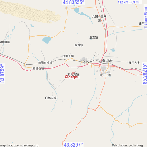
Xidagou GPS coordinates[2]
44° 20' 5.208" North, 84° 34' 44.472" East
| Map corner | latitude | longitude |
|---|---|---|
| Upper-left | 44.83555°, | 83.8759° |
| Center: | 44.33478°, | 84.57902° |
| Lower-right: | 43.8297°, | 85.28215° |
| Map W x H: | 111.8×111.8 km | = 69.5×69.5mi |
| max Lat: | 53.31946° ⇑6.8% North |
| Xidagou: | 44.33478° |
| min Lat: | ⇓93.2% South 18.22056° |
| min Long | Xidagou | max Long |
| 75.07348° | 84.57902° | 134.28917° |
| W 1.3%⇐ | ⇒98.7% E |
Elevation
Elevation of Xidagou is 632 m = 2073 ft, and this is 147.2 m = 483 ft above average elevation for this country.
| Max E: |
5622 m = 18445 ft | 21.5% |
| Xidagou | 632 m 2073 ft | |
| Avg. | 484.8 m = 1591 ft | |
Min E: |
-3 m = -10 ft | 78.5% |
See also: China elevation on elevation.city.
Geographical zone
Xidagou is located in North temperate zone (between Tropic of Cancer and the Arctic Circle). Distance of this Northern Tropic circle is 2323.6 km =1443.8 mi to South.| Distance of | km | miles | from Xidagou |
|---|---|---|---|
| North Pole | 5077.5 | 3155 | to North |
| Arctic Circle | 2471.6 | 1535.8 | to North |
| Tropic Cancer | 2323.6 | 1443.8 | to South |
| Equator | 4929.6 | 3063.1 | to South |


Nearby cities:
15 places around Xidagou: (largest is in red/bold)
• Baiquan
20.7 km =12.9 mi,  296°
296°
• Baiyanggou
31.6 km =19.6 mi,  226°
226°
• Bashisihu
16.2 km =10.1 mi,  41°
41°
• Dushanzi
21.6 km =13.4 mi,  90°
90°
• Ganhezi
14.6 km =9.1 mi,  343°
343°
• Hatu Buh
23.2 km =14.4 mi,  291°
291°
• Huanggong
31.5 km =19.6 mi,  28°
28°
• Huochezhan
26.4 km =16.4 mi,  72°
72°
• Jiahezi
23.4 km =14.5 mi,  45°
45°
• Jiujianlou
30.5 km =19 mi, 41°
• Kuytun
27.5 km =17.1 mi, 68°
• Sikeshu
28.4 km =17.6 mi,  278°
278°
• Tabulehete
28 km =17.4 mi,  242°
242°
• Usu
13.2 km =8.2 mi, 35°
• Xihu
22.5 km =14 mi,  9°
9°
Sources, notices
• [Note1] Compared only with cities in China existing in our database
• [Src1] Map data: © OpenStreetMap contributors (CC-BY-SA)
• [Src2] Other city data from geonames.org with taken over terms of usage.
• [Src3] Geographical zone / Annual Mean Temperature by Robert A. Rohde @ Wikipedia
