Akebielidou geodata
Akebielidou (Heilongjiang) is a seat of a fourth-order administrative division; located in China in Asia/Urumqi (GMT+6) time zone. In our database, there are 1268 cities with bigger population. Compared to other cities in China, 95.4% of cities are located further ↓South; 98.9% of cities are located further →East and 74.3% of cities have lower elevation than Akebielidou. Note1


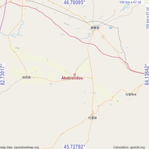
Akebielidou GPS coordinates[2]
46° 12' 59.724" North, 83° 25' 59.844" East
| Map corner | latitude | longitude |
|---|---|---|
| Upper-left | 46.70095°, | 82.73017° |
| Center: | 46.21659°, | 83.43329° |
| Lower-right: | 45.72792°, | 84.13642° |
| Map W x H: | 108.2×108.2 km | = 67.2×67.2mi |
| max Lat: | 53.31946° ⇑4.6% North |
| Akebielidou: | 46.21659° |
| min Lat: | ⇓95.4% South 18.22056° |
| min Long | Akebielidou | max Long |
| 75.07348° | 83.43329° | 134.28917° |
| W 1.1%⇐ | ⇒98.9% E |
Elevation
Elevation of Akebielidou is 506 m = 1660 ft, and this is 21.2 m = 70 ft above average elevation for this country.
| Max E: |
5622 m = 18445 ft | 25.7% |
| Akebielidou | 506 m 1660 ft | |
| Avg. | 484.8 m = 1591 ft | |
Min E: |
-3 m = -10 ft | 74.3% |
See also: China elevation on elevation.city.
Geographical zone
Akebielidou is located in North temperate zone (between Tropic of Cancer and the Arctic Circle). Distance of this North polar circle is 2262.4 km =1405.8 mi to North.| Distance of | km | miles | from Akebielidou |
|---|---|---|---|
| North Pole | 4868.3 | 3025 | to North |
| Arctic Circle | 2262.4 | 1405.8 | to North |
| Tropic Cancer | 2532.9 | 1573.9 | to South |
| Equator | 5138.8 | 3193.1 | to South |


Nearby cities:
15 places around Akebielidou: (largest is in red/bold)
• Altunemil
28.6 km =17.8 mi,  247°
247°
• Dolati
28.6 km =17.8 mi,  143°
143°
• Emil
55.2 km =34.3 mi,  330°
330°
• Emin
37.6 km =23.4 mi,  24°
24°
• Erdaoqiao
21.9 km =13.6 mi,  25°
25°
• Hujirti Mongolzuxiang
35.4 km =22 mi,  61°
61°
• Jelagax
56.8 km =35.3 mi,  41°
41°
• Jiaoqu
38.4 km =23.9 mi, 22°
• Karakabak
65.1 km =40.5 mi,  340°
340°
• Kupu
44.4 km =27.6 mi,  192°
192°
• Marelesu
34.7 km =21.6 mi, 36°
• Qaxa
52.5 km =32.6 mi,  357°
357°
• Shanghu
55.5 km =34.5 mi, 32°
• Toli
33.5 km =20.8 mi,  157°
157°
• Wuxuete
43 km =26.7 mi,  108°
108°
Sources, notices
• [Note1] Compared only with cities in China existing in our database
• [Src1] Map data: © OpenStreetMap contributors (CC-BY-SA)
• [Src2] Other city data from geonames.org with taken over terms of usage.
• [Src3] Geographical zone / Annual Mean Temperature by Robert A. Rohde @ Wikipedia
