Bulianhe geodata
Bulianhe (Inner Mongolia) is a seat of a fourth-order administrative division; located in China in Asia/Shanghai (GMT+8) time zone. In our database, there are 1268 cities with bigger population. Compared to other cities in China, 90.1% of cities are located further ↓South; 60% of cities are located further →East and 92.5% of cities have lower elevation than Bulianhe. Note1


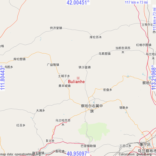
Bulianhe GPS coordinates[2]
41° 28' 47.568" North, 112° 30' 27.18" East
| Map corner | latitude | longitude |
|---|---|---|
| Upper-left | 42.00451°, | 111.80443° |
| Center: | 41.47988°, | 112.50755° |
| Lower-right: | 40.95097°, | 113.21068° |
| Map W x H: | 117.1×117.1 km | = 72.8×72.8mi |
| max Lat: | 53.31946° ⇑9.9% North |
| Bulianhe: | 41.47988° |
| min Lat: | ⇓90.1% South 18.22056° |
| min Long | Bulianhe | max Long |
| 75.07348° | 112.50755° | 134.28917° |
| W 40%⇐ | ⇒60% E |
Elevation
Elevation of Bulianhe is 1635 m = 5364 ft, and this is 1150.2 m = 3774 ft above average elevation for this country.
| Max E: |
5622 m = 18445 ft | 7.5% |
| Bulianhe | 1635 m 5364 ft | |
| Avg. | 484.8 m = 1591 ft | |
Min E: |
-3 m = -10 ft | 92.5% |
See also: China elevation on elevation.city.
Geographical zone
Bulianhe is located in North temperate zone (between Tropic of Cancer and the Arctic Circle). Distance of this Northern Tropic circle is 2006.2 km =1246.6 mi to South.| Distance of | km | miles | from Bulianhe |
|---|---|---|---|
| North Pole | 5394.9 | 3352.2 | to North |
| Arctic Circle | 2789 | 1733 | to North |
| Tropic Cancer | 2006.2 | 1246.6 | to South |
| Equator | 4612.1 | 2865.8 | to South |


Nearby cities:
15 places around Bulianhe: (largest is in red/bold)
• Bayin
19 km =11.8 mi,  32°
32°
• Erhaodi
22.6 km =14 mi,  191°
191°
• Guangchanglong
14.1 km =8.8 mi,  248°
248°
• Guangyilong
21.1 km =13.1 mi,  296°
296°
• Hobor
25.2 km =15.7 mi,  156°
156°
• Hongpan
23.9 km =14.9 mi,  110°
110°
• Huangyangcheng
11.6 km =7.2 mi,  242°
242°
• Huashanzi
25.5 km =15.8 mi,  309°
309°
• Miliangju
16.8 km =10.4 mi,  195°
195°
• Sandaogou
16.3 km =10.1 mi,  133°
133°
• Teshage
10.3 km =6.4 mi, 29°
• Touhao
25.2 km =15.7 mi,  219°
219°
• Tuchengzi
10.7 km =6.6 mi,  281°
281°
• Wuhao
18.6 km =11.6 mi,  288°
288°
• Yifaquan
16 km =9.9 mi,  5°
5°
Sources, notices
• [Note1] Compared only with cities in China existing in our database
• [Src1] Map data: © OpenStreetMap contributors (CC-BY-SA)
• [Src2] Other city data from geonames.org with taken over terms of usage.
• [Src3] Geographical zone / Annual Mean Temperature by Robert A. Rohde @ Wikipedia
