Sandaogou geodata
Sandaogou (Inner Mongolia) is a seat of a fourth-order administrative division; located in China in Asia/Shanghai (GMT+8) time zone. In our database, there are 1268 cities with bigger population. Compared to other cities in China, 89.9% of cities are located further ↓South; 59.3% of cities are located further →East and 93.1% of cities have lower elevation than Sandaogou. Note1


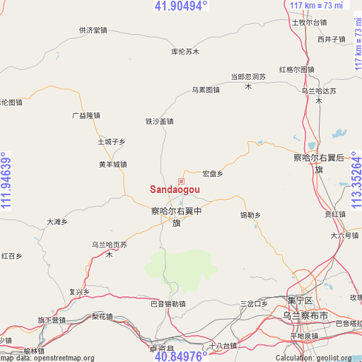
Sandaogou GPS coordinates[2]
41° 22' 46.164" North, 112° 38' 58.236" East
| Map corner | latitude | longitude |
|---|---|---|
| Upper-left | 41.90494°, | 111.94639° |
| Center: | 41.37949°, | 112.64951° |
| Lower-right: | 40.84976°, | 113.35264° |
| Map W x H: | 117.3×117.3 km | = 72.9×72.9mi |
| max Lat: | 53.31946° ⇑10.1% North |
| Sandaogou: | 41.37949° |
| min Lat: | ⇓89.9% South 18.22056° |
| min Long | Sandaogou | max Long |
| 75.07348° | 112.64951° | 134.28917° |
| W 40.7%⇐ | ⇒59.3% E |
Elevation
Elevation of Sandaogou is 1724 m = 5656 ft, and this is 1239.2 m = 4066 ft above average elevation for this country.
| Max E: |
5622 m = 18445 ft | 6.9% |
| Sandaogou | 1724 m 5656 ft | |
| Avg. | 484.8 m = 1591 ft | |
Min E: |
-3 m = -10 ft | 93.1% |
See also: China elevation on elevation.city.
Geographical zone
Sandaogou is located in North temperate zone (between Tropic of Cancer and the Arctic Circle). Distance of this Northern Tropic circle is 1995 km =1239.6 mi to South.| Distance of | km | miles | from Sandaogou |
|---|---|---|---|
| North Pole | 5406.1 | 3359.2 | to North |
| Arctic Circle | 2800.2 | 1740 | to North |
| Tropic Cancer | 1995 | 1239.6 | to South |
| Equator | 4601 | 2858.9 | to South |


Nearby cities:
15 places around Sandaogou: (largest is in red/bold)
• Bayin
27.2 km =16.9 mi,  356°
356°
• Bulianhe
16.3 km =10.1 mi,  313°
313°
• Erhaodi
19.7 km =12.2 mi,  236°
236°
• Guangchanglong
25.7 km =16 mi,  283°
283°
• Hobor
12.2 km =7.6 mi,  189°
189°
• Hongpan
10.9 km =6.8 mi,  75°
75°
• Huangyangcheng
22.9 km =14.2 mi, 284°
• Miliangju
17 km =10.6 mi,  252°
252°
• Qisumu
22.1 km =13.7 mi,  219°
219°
• Teshage
21.3 km =13.2 mi,  341°
341°
• Touhao
29.2 km =18.1 mi, 253°
• Tuchengzi
26 km =16.2 mi,  300°
300°
• Xilei
25.1 km =15.6 mi,  115°
115°
• Yifaquan
29 km =18 mi, 339°
• Yuanshanzi
10.5 km =6.5 mi,  148°
148°
Sources, notices
• [Note1] Compared only with cities in China existing in our database
• [Src1] Map data: © OpenStreetMap contributors (CC-BY-SA)
• [Src2] Other city data from geonames.org with taken over terms of usage.
• [Src3] Geographical zone / Annual Mean Temperature by Robert A. Rohde @ Wikipedia
