Wenfenglu geodata
Wenfenglu (Shandong) is a seat of a fourth-order administrative division; located in China in Asia/Shanghai (GMT+8) time zone. In our database, there are 1268 cities with bigger population. Compared to other cities in China, 79.5% of cities are located further ↓South; 81.4% of cities are located further ←West and 65.6% of cities have higher elevation than Wenfenglu. Note1


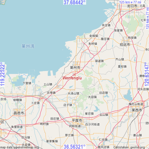
Wenfenglu GPS coordinates[2]
37° 7' 33.204" North, 119° 55' 42.024" East
| Map corner | latitude | longitude |
|---|---|---|
| Upper-left | 37.68442°, | 119.22522° |
| Center: | 37.12589°, | 119.92834° |
| Lower-right: | 36.56321°, | 120.63147° |
| Map W x H: | 124.7×124.7 km | = 77.5×77.5mi |
| max Lat: | 53.31946° ⇑20.5% North |
| Wenfenglu: | 37.12589° |
| min Lat: | ⇓79.5% South 18.22056° |
| min Long | Wenfenglu | max Long |
| 75.07348° | 119.92834° | 134.28917° |
| W 81.4%⇐ | ⇒18.6% E |
Elevation
Elevation of Wenfenglu is 70 m = 230 ft, and this is 414.8 m = 1361 ft below average elevation for this country.
| Max E: |
5622 m = 18445 ft | 65.6% |
| Avg. | 484.8 m = 1591 ft | |
| Wenfenglu | 70 m = 230 ft | |
Min E: |
-3 m = -10 ft | 34.4% |
See also: China elevation on elevation.city.
Geographical zone
Wenfenglu is located in North temperate zone (between Tropic of Cancer and the Arctic Circle). Distance of this Northern Tropic circle is 1522.1 km =945.8 mi to South.| Distance of | km | miles | from Wenfenglu |
|---|---|---|---|
| North Pole | 5879 | 3653 | to North |
| Arctic Circle | 3273.2 | 2033.9 | to North |
| Tropic Cancer | 1522.1 | 945.8 | to South |
| Equator | 4128 | 2565 | to South |


Nearby cities:
15 places around Wenfenglu: (largest is in red/bold)
• Chengguo
12.1 km =7.5 mi,  27°
27°
• Guojiadian
20.9 km =13 mi,  103°
103°
• Jincheng
36.3 km =22.6 mi, 25°
• Laizhou
6.2 km =3.9 mi,  11°
11°
• Longhuya
5.3 km =3.3 mi,  275°
275°
• Nanshu
38.1 km =23.7 mi,  107°
107°
• Pingdu
38 km =23.6 mi,  177°
177°
• Pinglidian
19.9 km =12.4 mi,  24°
24°
• Sanshandao
31.1 km =19.3 mi,  3°
3°
• Shahe
17.1 km =10.6 mi,  235°
235°
• Tushan
23.8 km =14.8 mi,  250°
250°
• Xiaqiu
13.4 km =8.3 mi,  189°
189°
• Yidao
23.7 km =14.7 mi,  60°
60°
• Zhuqiao
30.4 km =18.9 mi, 29°
• Zuocun
7.4 km =4.6 mi,  170°
170°
Sources, notices
• [Note1] Compared only with cities in China existing in our database
• [Src1] Map data: © OpenStreetMap contributors (CC-BY-SA)
• [Src2] Other city data from geonames.org with taken over terms of usage.
• [Src3] Geographical zone / Annual Mean Temperature by Robert A. Rohde @ Wikipedia
