Pinglidian geodata
Pinglidian (Shandong) is a seat of a fourth-order administrative division; located in China in Asia/Shanghai (GMT+8) time zone. In our database, there are 1268 cities with bigger population. Compared to other cities in China, 79.7% of cities are located further ↓South; 82.1% of cities are located further ←West and 80.2% of cities have higher elevation than Pinglidian. Note1


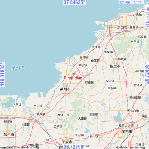
Pinglidian GPS coordinates[2]
37° 17' 20.508" North, 120° 1' 17.22" East
| Map corner | latitude | longitude |
|---|---|---|
| Upper-left | 37.84635°, | 119.31833° |
| Center: | 37.28903°, | 120.02145° |
| Lower-right: | 36.72756°, | 120.72458° |
| Map W x H: | 124.4×124.4 km | = 77.3×77.3mi |
| max Lat: | 53.31946° ⇑20.3% North |
| Pinglidian: | 37.28903° |
| min Lat: | ⇓79.7% South 18.22056° |
| min Long | Pinglidian | max Long |
| 75.07348° | 120.02145° | 134.28917° |
| W 82.1%⇐ | ⇒17.9% E |
Elevation
Elevation of Pinglidian is 26 m = 85 ft, and this is 458.8 m = 1505 ft below average elevation for this country.
| Max E: |
5622 m = 18445 ft | 80.2% |
| Avg. | 484.8 m = 1591 ft | |
| Pinglidian | 26 m = 85 ft | |
Min E: |
-3 m = -10 ft | 19.8% |
See also: China elevation on elevation.city.
Geographical zone
Pinglidian is located in North temperate zone (between Tropic of Cancer and the Arctic Circle). Distance of this Northern Tropic circle is 1540.2 km =957 mi to South.| Distance of | km | miles | from Pinglidian |
|---|---|---|---|
| North Pole | 5860.9 | 3641.8 | to North |
| Arctic Circle | 3255 | 2022.6 | to North |
| Tropic Cancer | 1540.2 | 957 | to South |
| Equator | 4146.2 | 2576.3 | to South |


Nearby cities:
15 places around Pinglidian: (largest is in red/bold)
• Canzhuang
20.8 km =12.9 mi,  54°
54°
• Chengguo
7.9 km =4.9 mi,  200°
200°
• Guojiadian
25.9 km =16.1 mi,  152°
152°
• Jincheng
16.4 km =10.2 mi,  27°
27°
• Jinling
27.2 km =16.9 mi,  63°
63°
• Laizhou
13.9 km =8.6 mi,  210°
210°
• Longhuya
22.2 km =13.8 mi,  217°
217°
• Qicai
29.7 km =18.5 mi,  99°
99°
• Sanshandao
14.3 km =8.9 mi,  334°
334°
• Wenfenglu
19.9 km =12.4 mi, 204°
• Xiaqiu
33 km =20.5 mi, 198°
• Xinzhuang
29.7 km =18.5 mi,  37°
37°
• Yidao
13.9 km =8.6 mi,  117°
117°
• Zhuqiao
10.6 km =6.6 mi, 38°
• Zuocun
26.4 km =16.4 mi, 195°
Sources, notices
• [Note1] Compared only with cities in China existing in our database
• [Src1] Map data: © OpenStreetMap contributors (CC-BY-SA)
• [Src2] Other city data from geonames.org with taken over terms of usage.
• [Src3] Geographical zone / Annual Mean Temperature by Robert A. Rohde @ Wikipedia
