Xincun geodata
Xincun (Yunnan) is a seat of a fourth-order administrative division; located in China in Asia/Shanghai (GMT+8) time zone. In our database, there are 1268 cities with bigger population. Compared to other cities in China, 75.9% of cities are located further ↑North; 90.5% of cities are located further →East and 89.2% of cities have lower elevation than Xincun. Note1


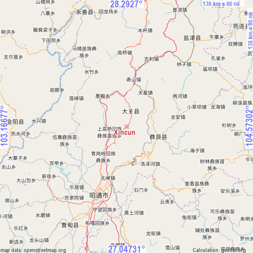
Xincun GPS coordinates[2]
27° 40' 18.408" North, 103° 52' 11.604" East
| Map corner | latitude | longitude |
|---|---|---|
| Upper-left | 28.2927°, | 103.16677° |
| Center: | 27.67178°, | 103.86989° |
| Lower-right: | 27.04731°, | 104.57302° |
| Map W x H: | 138.5×138.5 km | = 86.1×86.1mi |
| max Lat: | 53.31946° ⇑75.9% North |
| Xincun: | 27.67178° |
| min Lat: | ⇓24.1% South 18.22056° |
| min Long | Xincun | max Long |
| 75.07348° | 103.86989° | 134.28917° |
| W 9.5%⇐ | ⇒90.5% E |
Elevation
Elevation of Xincun is 1285 m = 4216 ft, and this is 800.2 m = 2625 ft above average elevation for this country.
| Max E: |
5622 m = 18445 ft | 10.8% |
| Xincun | 1285 m 4216 ft | |
| Avg. | 484.8 m = 1591 ft | |
Min E: |
-3 m = -10 ft | 89.2% |
See also: China elevation on elevation.city.
Geographical zone
Xincun is located in North temperate zone (between Tropic of Cancer and the Arctic Circle). Distance of this Northern Tropic circle is 470.9 km =292.6 mi to South.| Distance of | km | miles | from Xincun |
|---|---|---|---|
| North Pole | 6930.2 | 4306.2 | to North |
| Arctic Circle | 4324.4 | 2687.1 | to North |
| Tropic Cancer | 470.9 | 292.6 | to South |
| Equator | 3076.8 | 1911.8 | to South |


Nearby cities:
15 places around Xincun: (largest is in red/bold)
• Cuihua
7.4 km =4.6 mi,  350°
350°
• Huanggexi
20.3 km =12.6 mi,  357°
357°
• Huangjingba
40.1 km =24.9 mi,  18°
18°
• Jiaokui
15.8 km =9.8 mi,  123°
123°
• Moshiyi
22.2 km =13.8 mi,  321°
321°
• Pengjia Zhaizi
34.5 km =21.4 mi,  258°
258°
• Shangtianba
40 km =24.9 mi, 358°
• Shiziba
45.9 km =28.5 mi,  41°
41°
• Shuizhulin
35.9 km =22.3 mi,  327°
327°
• Tianxingchang
22 km =13.7 mi,  30°
30°
• Tiexianxi
26.8 km =16.7 mi,  4°
4°
• Wanhechang
37.3 km =23.2 mi,  288°
288°
• Xiaohebian
13.8 km =8.6 mi,  63°
63°
• Yuelejie
19.3 km =12 mi, 333°
• Zhaotong
42.3 km =26.3 mi,  200°
200°
Sources, notices
• [Note1] Compared only with cities in China existing in our database
• [Src1] Map data: © OpenStreetMap contributors (CC-BY-SA)
• [Src2] Other city data from geonames.org with taken over terms of usage.
• [Src3] Geographical zone / Annual Mean Temperature by Robert A. Rohde @ Wikipedia
