Pengjia Zhaizi geodata
Pengjia Zhaizi (Yunnan) is a seat of a fourth-order administrative division; located in China in Asia/Shanghai (GMT+8) time zone. In our database, there are 1268 cities with bigger population. Compared to other cities in China, 76.2% of cities are located further ↑North; 90.9% of cities are located further →East and 95.5% of cities have lower elevation than Pengjia Zhaizi. Note1


Pengjia Zhaizi GPS coordinates[2]
27° 36' 29.88" North, 103° 31' 37.56" East
| Map corner | latitude | longitude |
|---|---|---|
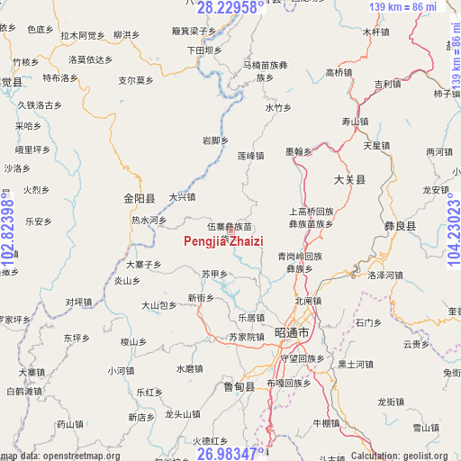
| Upper-left | 28.22958°, | 102.82398° |
| Center: | 27.6083°, | 103.5271° |
| Lower-right: | 26.98347°, | 104.23023° |
| Map W x H: | 138.6×138.6 km | = 86.1×86.1mi |
| max Lat: | 53.31946° ⇑76.2% North |
| Pengjia Zhaizi: | 27.6083° |
| min Lat: | ⇓23.8% South 18.22056° |
| min Long | Pengjia Zhaizi | max Long |
| 75.07348° | 103.5271° | 134.28917° |
| W 9.1%⇐ | ⇒90.9% E |
Elevation
Elevation of Pengjia Zhaizi is 2298 m = 7539 ft, and this is 1813.2 m = 5949 ft above average elevation for this country.
| Max E: |
5622 m = 18445 ft | 4.5% |
| Pengjia Zhaizi | 2298 m 7539 ft | |
| Avg. | 484.8 m = 1591 ft | |
Min E: |
-3 m = -10 ft | 95.5% |
See also: China elevation on elevation.city.
Geographical zone
Pengjia Zhaizi is located in North temperate zone (between Tropic of Cancer and the Arctic Circle). Distance of this Northern Tropic circle is 463.8 km =288.2 mi to South.| Distance of | km | miles | from Pengjia Zhaizi |
|---|---|---|---|
| North Pole | 6937.3 | 4310.6 | to North |
| Arctic Circle | 4331.4 | 2691.4 | to North |
| Tropic Cancer | 463.8 | 288.2 | to South |
| Equator | 3069.8 | 1907.5 | to South |


Nearby cities:
15 places around Pengjia Zhaizi: (largest is in red/bold)
• Cuihua
35.6 km =22.1 mi,  66°
66°
• Daliyuan
47.4 km =29.5 mi,  184°
184°
• Huanggexi
42.7 km =26.5 mi,  50°
50°
• Jiaokui
47.1 km =29.3 mi,  91°
91°
• Moshiyi
31.4 km =19.5 mi,  39°
39°
• Shuizhulin
40.1 km =24.9 mi,  21°
21°
• Tiandiba
29.4 km =18.3 mi,  290°
290°
• Tianxingchang
51.8 km =32.2 mi,  59°
59°
• Tiexianxi
49.1 km =30.5 mi, 46°
• Wanhechang
18.7 km =11.6 mi,  354°
354°
• Wenping
46.2 km =28.7 mi, 179°
• Xiaohebian
48 km =29.8 mi, 73°
• Xincun
34.5 km =21.4 mi,  78°
78°
• Yuelejie
35 km =21.7 mi, 46°
• Zhaotong
37.4 km =23.2 mi,  150°
150°
Sources, notices
• [Note1] Compared only with cities in China existing in our database
• [Src1] Map data: © OpenStreetMap contributors (CC-BY-SA)
• [Src2] Other city data from geonames.org with taken over terms of usage.
• [Src3] Geographical zone / Annual Mean Temperature by Robert A. Rohde @ Wikipedia
