Zhaotong geodata
Zhaotong (Yunnan) is a populated place; located in China in Asia/Shanghai (GMT+8) time zone. With population of 109,400 people, there are 401 cities with bigger population in this country. Compared to other cities in China, 77.4% of cities are located further ↑North; 90.7% of cities are located further →East and 94.6% of cities have lower elevation than Zhaotong. Note1


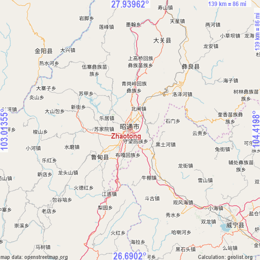
Zhaotong GPS coordinates[2]
27° 19' 0.012" North, 103° 43' 0.012" East
| Map corner | latitude | longitude |
|---|---|---|
| Upper-left | 27.93962°, | 103.01355° |
| Center: | 27.31667°, | 103.71667° |
| Lower-right: | 26.6902°, | 104.4198° |
| Map W x H: | 138.9×138.9 km | = 86.3×86.3mi |
| max Lat: | 53.31946° ⇑77.4% North |
| Zhaotong: | 27.31667° |
| min Lat: | ⇓22.6% South 18.22056° |
| min Long | Zhaotong | max Long |
| 75.07348° | 103.71667° | 134.28917° |
| W 9.3%⇐ | ⇒90.7% E |
Elevation
Elevation of Zhaotong is 1974 m = 6476 ft, and this is 1489.2 m = 4886 ft above average elevation for this country.
| Max E: |
5622 m = 18445 ft | 5.4% |
| Zhaotong | 1974 m 6476 ft | |
| Avg. | 484.8 m = 1591 ft | |
Min E: |
-3 m = -10 ft | 94.6% |
See also: Zhaotong elevation on elevation.city.
Geographical zone
Zhaotong is located in North temperate zone (between Tropic of Cancer and the Arctic Circle). Distance of this Northern Tropic circle is 431.4 km =268.1 mi to South.| Distance of | km | miles | from Zhaotong |
|---|---|---|---|
| North Pole | 6969.7 | 4330.8 | to North |
| Arctic Circle | 4363.8 | 2711.5 | to North |
| Tropic Cancer | 431.4 | 268.1 | to South |
| Equator | 3037.3 | 1887.3 | to South |


Nearby cities:
15 places around Zhaotong: (largest is in red/bold)
• Cuihua
48.8 km =30.3 mi,  16°
16°
• Daliyuan
27.1 km =16.8 mi,  236°
236°
• Guji
45.8 km =28.5 mi,  249°
249°
• Huanggexi
61.4 km =38.2 mi,  13°
13°
• Jiaokui
42 km =26.1 mi,  42°
42°
• Laodianzi
60 km =37.3 mi,  224°
224°
• Moshiyi
56.8 km =35.3 mi,  1°
1°
• Pengjia Zhaizi
37.4 km =23.2 mi,  330°
330°
• Sanguanzhai
51.1 km =31.8 mi, 242°
• Shuigou’ao
42.1 km =26.2 mi, 238°
• Wanhechang
55 km =34.2 mi,  338°
338°
• Wenping
23.2 km =14.4 mi,  233°
233°
• Xiaohebian
53.3 km =33.1 mi,  31°
31°
• Xincun
42.3 km =26.3 mi, 20°
• Yuelejie
57.1 km =35.5 mi, 6°
Sources, notices
• [Note1] Compared only with cities in China existing in our database
• [Src1] Map data: © OpenStreetMap contributors (CC-BY-SA)
• [Src2] Other city data from geonames.org with taken over terms of usage.
• [Src3] Geographical zone / Annual Mean Temperature by Robert A. Rohde @ Wikipedia
