Yantak geodata
Yantak (Xinjiang) is a seat of a fourth-order administrative division; located in China in Asia/Urumqi (GMT+6) time zone. In our database, there are 1268 cities with bigger population. Compared to other cities in China, 82.7% of cities are located further ↓South; 99.7% of cities are located further →East and 87.9% of cities have lower elevation than Yantak. Note1


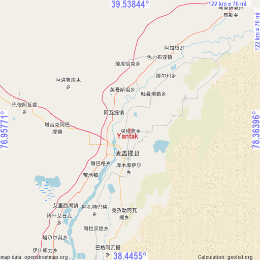
Yantak GPS coordinates[2]
38° 59' 38.688" North, 77° 39' 38.988" East
| Map corner | latitude | longitude |
|---|---|---|
| Upper-left | 39.53844°, | 76.95771° |
| Center: | 38.99408°, | 77.66083° |
| Lower-right: | 38.4455°, | 78.36396° |
| Map W x H: | 121.5×121.5 km | = 75.5×75.5mi |
| max Lat: | 53.31946° ⇑17.3% North |
| Yantak: | 38.99408° |
| min Lat: | ⇓82.7% South 18.22056° |
| min Long | Yantak | max Long |
| 75.07348° | 77.66083° | 134.28917° |
| W 0.3%⇐ | ⇒99.7% E |
Elevation
Elevation of Yantak is 1173 m = 3848 ft, and this is 688.2 m = 2258 ft above average elevation for this country.
| Max E: |
5622 m = 18445 ft | 12.1% |
| Yantak | 1173 m 3848 ft | |
| Avg. | 484.8 m = 1591 ft | |
Min E: |
-3 m = -10 ft | 87.9% |
See also: China elevation on elevation.city.
Geographical zone
Yantak is located in North temperate zone (between Tropic of Cancer and the Arctic Circle). Distance of this Northern Tropic circle is 1729.8 km =1074.8 mi to South.| Distance of | km | miles | from Yantak |
|---|---|---|---|
| North Pole | 5671.3 | 3524 | to North |
| Arctic Circle | 3065.4 | 1904.8 | to North |
| Tropic Cancer | 1729.8 | 1074.8 | to South |
| Equator | 4335.7 | 2694.1 | to South |


Nearby cities:
15 places around Yantak: (largest is in red/bold)
• Ahonglukumu
36.4 km =22.6 mi,  307°
307°
• Alage’er
44 km =27.3 mi,  28°
28°
• Bayi’awati
50.9 km =31.6 mi,  282°
282°
• Serikbuya
36.8 km =22.9 mi,  21°
21°
• Seyeke
89.3 km =55.5 mi,  285°
285°
• Shache
73.8 km =45.9 mi,  209°
209°
• Tajike’abati
47.8 km =29.7 mi, 281°
• Tieremu
59.5 km =37 mi, 284°
• Tumantale
20.6 km =12.8 mi, 32°
• Wolituogelake
84.3 km =52.4 mi,  337°
337°
• Yingmaili
93.7 km =58.2 mi, 307°
• Yingwusitang
19.4 km =12.1 mi,  349°
349°
• Yopurga
82 km =51 mi, 289°
• Yudaikelike
80.1 km =49.8 mi,  5°
5°
• Yukuriawat
12.8 km =8 mi,  320°
320°
Sources, notices
• [Note1] Compared only with cities in China existing in our database
• [Src1] Map data: © OpenStreetMap contributors (CC-BY-SA)
• [Src2] Other city data from geonames.org with taken over terms of usage.
• [Src3] Geographical zone / Annual Mean Temperature by Robert A. Rohde @ Wikipedia
