Tumantale geodata
Tumantale (Xinjiang) is a seat of a fourth-order administrative division; located in China in Asia/Urumqi (GMT+6) time zone. In our database, there are 1268 cities with bigger population. Compared to other cities in China, 83.5% of cities are located further ↓South; 99.7% of cities are located further →East and 87.7% of cities have lower elevation than Tumantale. Note1


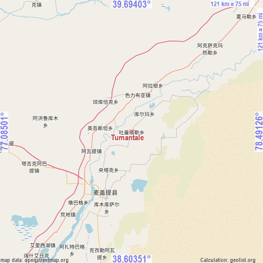
Tumantale GPS coordinates[2]
39° 9' 3.168" North, 77° 47' 17.268" East
| Map corner | latitude | longitude |
|---|---|---|
| Upper-left | 39.69403°, | 77.08501° |
| Center: | 39.15088°, | 77.78813° |
| Lower-right: | 38.60351°, | 78.49126° |
| Map W x H: | 121.3×121.3 km | = 75.4×75.4mi |
| max Lat: | 53.31946° ⇑16.5% North |
| Tumantale: | 39.15088° |
| min Lat: | ⇓83.5% South 18.22056° |
| min Long | Tumantale | max Long |
| 75.07348° | 77.78813° | 134.28917° |
| W 0.3%⇐ | ⇒99.7% E |
Elevation
Elevation of Tumantale is 1162 m = 3812 ft, and this is 677.2 m = 2222 ft above average elevation for this country.
| Max E: |
5622 m = 18445 ft | 12.3% |
| Tumantale | 1162 m 3812 ft | |
| Avg. | 484.8 m = 1591 ft | |
Min E: |
-3 m = -10 ft | 87.7% |
See also: China elevation on elevation.city.
Geographical zone
Tumantale is located in North temperate zone (between Tropic of Cancer and the Arctic Circle). Distance of this Northern Tropic circle is 1747.3 km =1085.7 mi to South.| Distance of | km | miles | from Tumantale |
|---|---|---|---|
| North Pole | 5653.9 | 3513.2 | to North |
| Arctic Circle | 3048 | 1893.9 | to North |
| Tropic Cancer | 1747.3 | 1085.7 | to South |
| Equator | 4353.2 | 2705 | to South |


Nearby cities:
15 places around Tumantale: (largest is in red/bold)
• Ahonglukumu
40.1 km =24.9 mi,  276°
276°
• Alage’er
23.4 km =14.5 mi,  24°
24°
• Bayi’awati
61.1 km =38 mi,  263°
263°
• Serikbuya
17 km =10.6 mi,  8°
8°
• Shache
94.4 km =58.7 mi,  210°
210°
• Tajike’abati
58.4 km =36.3 mi, 261°
• Tieremu
68.5 km =42.6 mi,  268°
268°
• Wolituogelake
74.4 km =46.2 mi,  323°
323°
• Xekar
82.3 km =51.1 mi,  333°
333°
• Yantak
20.6 km =12.8 mi, 212°
• Yingmaili
93.8 km =58.3 mi,  295°
295°
• Yingwusitang
14.6 km =9.1 mi, 276°
• Yopurga
88.8 km =55.2 mi, 276°
• Yudaikelike
62.5 km =38.8 mi,  356°
356°
• Yukuriawat
20.5 km =12.7 mi,  248°
248°
Sources, notices
• [Note1] Compared only with cities in China existing in our database
• [Src1] Map data: © OpenStreetMap contributors (CC-BY-SA)
• [Src2] Other city data from geonames.org with taken over terms of usage.
• [Src3] Geographical zone / Annual Mean Temperature by Robert A. Rohde @ Wikipedia
