Shache geodata
Shache (Xinjiang) is a populated place; located in China in Asia/Urumqi (GMT+6) time zone. With population of 82,509 people, there are 517 cities with bigger population in this country. Compared to other cities in China, 81.7% of cities are located further ↓South; 99.8% of cities are located further →East and 88.6% of cities have lower elevation than Shache. Note1


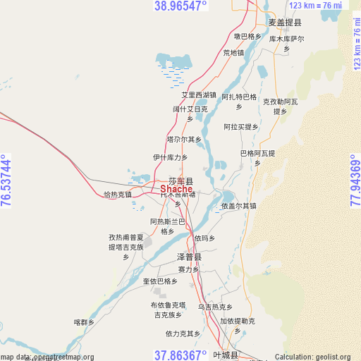
Shache GPS coordinates[2]
38° 25' 0.012" North, 77° 14' 26.016" East
| Map corner | latitude | longitude |
|---|---|---|
| Upper-left | 38.96547°, | 76.53744° |
| Center: | 38.41667°, | 77.24056° |
| Lower-right: | 37.86367°, | 77.94369° |
| Map W x H: | 122.5×122.5 km | = 76.1×76.1mi |
| max Lat: | 53.31946° ⇑18.3% North |
| Shache: | 38.41667° |
| min Lat: | ⇓81.7% South 18.22056° |
| min Long | Shache | max Long |
| 75.07348° | 77.24056° | 134.28917° |
| W 0.2%⇐ | ⇒99.8% E |
Elevation
Elevation of Shache is 1236 m = 4055 ft, and this is 751.2 m = 2465 ft above average elevation for this country.
| Max E: |
5622 m = 18445 ft | 11.4% |
| Shache | 1236 m 4055 ft | |
| Avg. | 484.8 m = 1591 ft | |
Min E: |
-3 m = -10 ft | 88.6% |
See also: Shache elevation on elevation.city.
Geographical zone
Shache is located in North temperate zone (between Tropic of Cancer and the Arctic Circle). Distance of this Northern Tropic circle is 1665.6 km =1035 mi to South.| Distance of | km | miles | from Shache |
|---|---|---|---|
| North Pole | 5735.5 | 3563.9 | to North |
| Arctic Circle | 3129.6 | 1944.6 | to North |
| Tropic Cancer | 1665.6 | 1035 | to South |
| Equator | 4271.5 | 2654.2 | to South |


Nearby cities:
15 places around Shache: (largest is in red/bold)
• Ahonglukumu
86.7 km =53.9 mi,  4°
4°
• Aqqik
97.8 km =60.8 mi,  323°
323°
• Bayi’awati
76.1 km =47.3 mi,  349°
349°
• Kezilei
72.1 km =44.8 mi,  291°
291°
• Saxin
99.1 km =61.6 mi,  305°
305°
• Tajike’abati
74.1 km =46 mi, 351°
• Tieremu
82.2 km =51.1 mi,  344°
344°
• Tumantale
94.4 km =58.7 mi,  30°
30°
• Tuopu Luke
89.8 km =55.8 mi,  295°
295°
• Yantak
73.8 km =45.9 mi, 29°
• Yigezi Ye’er
94.3 km =58.6 mi, 285°
• Yilkiqi
50.7 km =31.5 mi,  179°
179°
• Yingwusitang
89.5 km =55.6 mi,  21°
21°
• Yukuriawat
79.3 km =49.3 mi, 20°
• Zepu
25.5 km =15.8 mi,  174°
174°
Sources, notices
• [Note1] Compared only with cities in China existing in our database
• [Src1] Map data: © OpenStreetMap contributors (CC-BY-SA)
• [Src2] Other city data from geonames.org with taken over terms of usage.
• [Src3] Geographical zone / Annual Mean Temperature by Robert A. Rohde @ Wikipedia
