Tacheng geodata
Tacheng (Xinjiang) is a seat of a third-order administrative division; located in China in Asia/Urumqi (GMT+6) time zone. In our database, there are 1268 cities with bigger population. Compared to other cities in China, 96.4% of cities are located further ↓South; 99% of cities are located further →East and 76% of cities have lower elevation than Tacheng. Note1


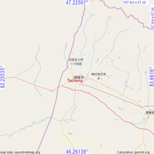
Tacheng GPS coordinates[2]
46° 44' 43.26" North, 82° 57' 30.492" East
| Map corner | latitude | longitude |
|---|---|---|
| Upper-left | 47.22501°, | 82.25535° |
| Center: | 46.74535°, | 82.95847° |
| Lower-right: | 46.26139°, | 83.6616° |
| Map W x H: | 107.1×107.1 km | = 66.5×66.5mi |
| max Lat: | 53.31946° ⇑3.6% North |
| Tacheng: | 46.74535° |
| min Lat: | ⇓96.4% South 18.22056° |
| min Long | Tacheng | max Long |
| 75.07348° | 82.95847° | 134.28917° |
| W 1%⇐ | ⇒99% E |
Elevation
Elevation of Tacheng is 546 m = 1791 ft, and this is 61.2 m = 201 ft above average elevation for this country.
| Max E: |
5622 m = 18445 ft | 24% |
| Tacheng | 546 m 1791 ft | |
| Avg. | 484.8 m = 1591 ft | |
Min E: |
-3 m = -10 ft | 76% |
See also: China elevation on elevation.city.
Geographical zone
Tacheng is located in North temperate zone (between Tropic of Cancer and the Arctic Circle). Distance of this North polar circle is 2203.6 km =1369.3 mi to North.| Distance of | km | miles | from Tacheng |
|---|---|---|---|
| North Pole | 4809.5 | 2988.5 | to North |
| Arctic Circle | 2203.6 | 1369.3 | to North |
| Tropic Cancer | 2591.7 | 1610.4 | to South |
| Equator | 5197.6 | 3229.6 | to South |


Nearby cities:
15 places around Tacheng: (largest is in red/bold)
• Abudula
26.6 km =16.5 mi,  65°
65°
• Akebielidou
69.1 km =42.9 mi,  148°
148°
• Altunemil
70.3 km =43.7 mi,  171°
171°
• Axili
17.6 km =10.9 mi,  45°
45°
• Emalgolin Mongolzuxiang
80.4 km =50 mi,  95°
95°
• Emil
14 km =8.7 mi,  141°
141°
• Emin
57 km =35.4 mi,  115°
115°
• Erdaoqiao
60.1 km =37.3 mi,  130°
130°
• Hujirti Mongolzuxiang
79.1 km =49.2 mi, 121°
• Jelagax
75.1 km =46.7 mi, 102°
• Jiaoqu
56.3 km =35 mi,  114°
114°
• Karakabak
14.6 km =9.1 mi,  80°
80°
• Marelesu
64.8 km =40.3 mi, 118°
• Qaxa
34.6 km =21.5 mi, 100°
• Shanghu
67.1 km =41.7 mi, 100°
Sources, notices
• [Note1] Compared only with cities in China existing in our database
• [Src1] Map data: © OpenStreetMap contributors (CC-BY-SA)
• [Src2] Other city data from geonames.org with taken over terms of usage.
• [Src3] Geographical zone / Annual Mean Temperature by Robert A. Rohde @ Wikipedia
