Sikeshu geodata
Sikeshu (Xinjiang) is a seat of a fourth-order administrative division; located in China in Asia/Urumqi (GMT+6) time zone. In our database, there are 1268 cities with bigger population. Compared to other cities in China, 93.3% of cities are located further ↓South; 98.8% of cities are located further →East and 74.1% of cities have lower elevation than Sikeshu. Note1


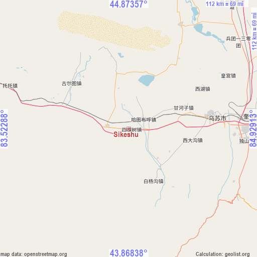
Sikeshu GPS coordinates[2]
44° 22' 23.268" North, 84° 13' 33.6" East
| Map corner | latitude | longitude |
|---|---|---|
| Upper-left | 44.87357°, | 83.52288° |
| Center: | 44.37313°, | 84.226° |
| Lower-right: | 43.86838°, | 84.92913° |
| Map W x H: | 111.8×111.8 km | = 69.5×69.5mi |
| max Lat: | 53.31946° ⇑6.7% North |
| Sikeshu: | 44.37313° |
| min Lat: | ⇓93.3% South 18.22056° |
| min Long | Sikeshu | max Long |
| 75.07348° | 84.226° | 134.28917° |
| W 1.2%⇐ | ⇒98.8% E |
Elevation
Elevation of Sikeshu is 503 m = 1650 ft, and this is 18.2 m = 60 ft above average elevation for this country.
| Max E: |
5622 m = 18445 ft | 25.9% |
| Sikeshu | 503 m 1650 ft | |
| Avg. | 484.8 m = 1591 ft | |
Min E: |
-3 m = -10 ft | 74.1% |
See also: China elevation on elevation.city.
Geographical zone
Sikeshu is located in North temperate zone (between Tropic of Cancer and the Arctic Circle). Distance of this Northern Tropic circle is 2327.9 km =1446.5 mi to South.| Distance of | km | miles | from Sikeshu |
|---|---|---|---|
| North Pole | 5073.2 | 3152.3 | to North |
| Arctic Circle | 2467.3 | 1533.1 | to North |
| Tropic Cancer | 2327.9 | 1446.5 | to South |
| Equator | 4933.8 | 3065.7 | to South |


Nearby cities:
15 places around Sikeshu: (largest is in red/bold)
• Baiquan
10.7 km =6.6 mi,  62°
62°
• Baiyanggou
26.7 km =16.6 mi,  168°
168°
• Bashisihu
39.5 km =24.5 mi,  78°
78°
• Dushanzi
49.8 km =30.9 mi,  95°
95°
• Ganhezi
25.9 km =16.1 mi,  67°
67°
• Hatu Buh
7.7 km =4.8 mi, 56°
• Huanggong
49.1 km =30.5 mi, 61°
• Jiahezi
46.3 km =28.8 mi, 74°
• Jiujianlou
51.6 km =32.1 mi, 68°
• Ji’ergele Teguoleng
4.2 km =2.6 mi,  242°
242°
• Tabulehete
17.5 km =10.9 mi, 169°
• Toutai
50.8 km =31.6 mi,  39°
39°
• Usu
36.3 km =22.6 mi, 79°
• Xidagou
28.4 km =17.6 mi, 98°
• Xihu
36.5 km =22.7 mi, 60°
Sources, notices
• [Note1] Compared only with cities in China existing in our database
• [Src1] Map data: © OpenStreetMap contributors (CC-BY-SA)
• [Src2] Other city data from geonames.org with taken over terms of usage.
• [Src3] Geographical zone / Annual Mean Temperature by Robert A. Rohde @ Wikipedia
