Guanyinsi geodata
Guanyinsi (Jiangsu) is a seat of a fourth-order administrative division; located in China in Asia/Shanghai (GMT+8) time zone. In our database, there are 1268 cities with bigger population. Compared to other cities in China, 66.6% of cities are located further ↓South; 83.1% of cities are located further ←West and 99.9% of cities have higher elevation than Guanyinsi. Note1


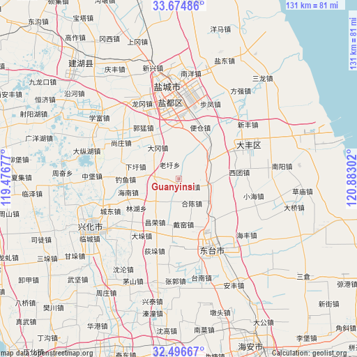
Guanyinsi GPS coordinates[2]
33° 5' 15.864" North, 120° 10' 47.604" East
| Map corner | latitude | longitude |
|---|---|---|
| Upper-left | 33.67486°, | 119.47677° |
| Center: | 33.08774°, | 120.17989° |
| Lower-right: | 32.49667°, | 120.88302° |
| Map W x H: | 131×131 km | = 81.4×81.4mi |
| max Lat: | 53.31946° ⇑33.4% North |
| Guanyinsi: | 33.08774° |
| min Lat: | ⇓66.6% South 18.22056° |
| min Long | Guanyinsi | max Long |
| 75.07348° | 120.17989° | 134.28917° |
| W 83.1%⇐ | ⇒16.9% E |
Elevation
Elevation of Guanyinsi is 0 m = 0 ft, and this is 484.8 m = 1591 ft below average elevation for this country.
| Max E: |
5622 m = 18445 ft | 99.9% |
| Avg. | 484.8 m = 1591 ft | |
| Guanyinsi | 0 m = 0 ft | |
Min E: |
-3 m = -10 ft | 0.1% |
See also: China elevation on elevation.city.
Geographical zone
Guanyinsi is located in North temperate zone (between Tropic of Cancer and the Arctic Circle). Distance of this Northern Tropic circle is 1073.1 km =666.8 mi to South.| Distance of | km | miles | from Guanyinsi |
|---|---|---|---|
| North Pole | 6328.1 | 3932.1 | to North |
| Arctic Circle | 3722.2 | 2312.9 | to North |
| Tropic Cancer | 1073.1 | 666.8 | to South |
| Equator | 3679 | 2286 | to South |


Nearby cities:
15 places around Guanyinsi: (largest is in red/bold)
• Anfeng
7.8 km =4.8 mi,  271°
271°
• Baiju
12.2 km =7.6 mi,  100°
100°
• Caoyan
18.9 km =11.7 mi,  145°
145°
• Changrong
18.5 km =11.5 mi,  210°
210°
• Daduo
25.2 km =15.7 mi, 212°
• Daiyao
17.9 km =11.1 mi,  169°
169°
• Diaoyumiao
19.2 km =11.9 mi, 269°
• Gaojiazhuang
19 km =11.8 mi,  255°
255°
• Hechen
10.5 km =6.5 mi, 149°
• Lianyi
21.7 km =13.5 mi, 165°
• Liuzhuang
11.9 km =7.4 mi,  62°
62°
• Tangzi
19.1 km =11.9 mi, 208°
• Taozhuang
24.9 km =15.5 mi,  188°
188°
• Wulie
26.1 km =16.2 mi, 167°
• Xituan
22.3 km =13.9 mi,  83°
83°
Sources, notices
• [Note1] Compared only with cities in China existing in our database
• [Src1] Map data: © OpenStreetMap contributors (CC-BY-SA)
• [Src2] Other city data from geonames.org with taken over terms of usage.
• [Src3] Geographical zone / Annual Mean Temperature by Robert A. Rohde @ Wikipedia
