Dinghuo geodata
Dinghuo (Jiangsu) is a seat of a fourth-order administrative division; located in China in Asia/Shanghai (GMT+8) time zone. In our database, there are 1268 cities with bigger population. Compared to other cities in China, 64.1% of cities are located further ↓South; 79.5% of cities are located further ←West and 92.7% of cities have higher elevation than Dinghuo. Note1


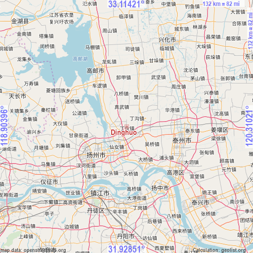
Dinghuo GPS coordinates[2]
32° 31' 23.952" North, 119° 36' 25.488" East
| Map corner | latitude | longitude |
|---|---|---|
| Upper-left | 33.11421°, | 118.90396° |
| Center: | 32.52332°, | 119.60708° |
| Lower-right: | 31.92851°, | 120.31021° |
| Map W x H: | 131.8×131.8 km | = 81.9×81.9mi |
| max Lat: | 53.31946° ⇑35.9% North |
| Dinghuo: | 32.52332° |
| min Lat: | ⇓64.1% South 18.22056° |
| min Long | Dinghuo | max Long |
| 75.07348° | 119.60708° | 134.28917° |
| W 79.5%⇐ | ⇒20.5% E |
Elevation
Elevation of Dinghuo is 8 m = 26 ft, and this is 476.8 m = 1564 ft below average elevation for this country.
| Max E: |
5622 m = 18445 ft | 92.7% |
| Avg. | 484.8 m = 1591 ft | |
| Dinghuo | 8 m = 26 ft | |
Min E: |
-3 m = -10 ft | 7.3% |
See also: China elevation on elevation.city.
Geographical zone
Dinghuo is located in North temperate zone (between Tropic of Cancer and the Arctic Circle). Distance of this Northern Tropic circle is 1010.3 km =627.8 mi to South.| Distance of | km | miles | from Dinghuo |
|---|---|---|---|
| North Pole | 6390.8 | 3971.1 | to North |
| Arctic Circle | 3784.9 | 2351.8 | to North |
| Tropic Cancer | 1010.3 | 627.8 | to South |
| Equator | 3616.3 | 2247.1 | to South |


Nearby cities:
15 places around Dinghuo: (largest is in red/bold)
• Baqiao
17.5 km =10.9 mi,  352°
352°
• Chengbei
19.1 km =11.9 mi,  233°
233°
• Daqiao
19.4 km =12.1 mi,  151°
151°
• Dinggou
6.9 km =4.3 mi,  48°
48°
• Fanchuan
17.4 km =10.8 mi,  24°
24°
• Guocun
16.9 km =10.5 mi,  84°
84°
• Hangji
18.6 km =11.6 mi,  201°
201°
• Shaobo
9.5 km =5.9 mi,  275°
275°
• Tai’an
11.6 km =7.2 mi, 231°
• Wantou
15.6 km =9.7 mi, 225°
• Wuqiao
17 km =10.6 mi,  125°
125°
• Xiannü
11.5 km =7.1 mi, 202°
• Xiaoji
18.7 km =11.6 mi, 52°
• Yiling
7.8 km =4.8 mi, 126°
• Zhenwu
10.8 km =6.7 mi,  344°
344°
Sources, notices
• [Note1] Compared only with cities in China existing in our database
• [Src1] Map data: © OpenStreetMap contributors (CC-BY-SA)
• [Src2] Other city data from geonames.org with taken over terms of usage.
• [Src3] Geographical zone / Annual Mean Temperature by Robert A. Rohde @ Wikipedia
