Xiannü geodata
Xiannü (Jiangsu) is a seat of a third-order administrative division; located in China in Asia/Shanghai (GMT+8) time zone. With population of 83,936 people, there are 506 cities with bigger population in this country. Compared to other cities in China, 63.7% of cities are located further ↓South; 79.2% of cities are located further ←West and 86.9% of cities have higher elevation than Xiannü. Note1


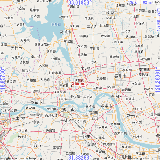
Xiannü GPS coordinates[2]
32° 25' 41.016" North, 119° 33' 37.728" East
| Map corner | latitude | longitude |
|---|---|---|
| Upper-left | 33.01958°, | 118.85736° |
| Center: | 32.42806°, | 119.56048° |
| Lower-right: | 31.83263°, | 120.26361° |
| Map W x H: | 132×132 km | = 82×82mi |
| max Lat: | 53.31946° ⇑36.3% North |
| Xiannü: | 32.42806° |
| min Lat: | ⇓63.7% South 18.22056° |
| min Long | Xiannü | max Long |
| 75.07348° | 119.56048° | 134.28917° |
| W 79.2%⇐ | ⇒20.8% E |
Elevation
Elevation of Xiannü is 13 m = 43 ft, and this is 471.8 m = 1548 ft below average elevation for this country.
| Max E: |
5622 m = 18445 ft | 86.9% |
| Avg. | 484.8 m = 1591 ft | |
| Xiannü | 13 m = 43 ft | |
Min E: |
-3 m = -10 ft | 13.1% |
See also: Xiannü elevation on elevation.city.
Geographical zone
Xiannü is located in North temperate zone (between Tropic of Cancer and the Arctic Circle). Distance of this Northern Tropic circle is 999.7 km =621.2 mi to South.| Distance of | km | miles | from Xiannü |
|---|---|---|---|
| North Pole | 6401.4 | 3977.6 | to North |
| Arctic Circle | 3795.5 | 2358.4 | to North |
| Tropic Cancer | 999.7 | 621.2 | to South |
| Equator | 3605.7 | 2240.5 | to South |


Nearby cities:
15 places around Xiannü: (largest is in red/bold)
• Chengbei
11.1 km =6.9 mi,  266°
266°
• Daqiao
15.1 km =9.4 mi,  115°
115°
• Dinghuo
11.5 km =7.1 mi,  22°
22°
• Hangji
7.1 km =4.4 mi,  201°
201°
• Lidian
11.9 km =7.4 mi,  172°
172°
• Pingshan
14.6 km =9.1 mi, 269°
• Shaobo
12.5 km =7.8 mi,  336°
336°
• Shatou
13.8 km =8.6 mi, 195°
• Shouxihu
14.7 km =9.1 mi, 266°
• Tai’an
5.7 km =3.5 mi,  305°
305°
• Tangwang
11.5 km =7.1 mi,  235°
235°
• Wantou
6.8 km =4.2 mi, 267°
• Wenhe
13.1 km =8.1 mi,  253°
253°
• Yangzhou
12.2 km =7.6 mi, 253°
• Yiling
12.2 km =7.6 mi,  60°
60°
Sources, notices
• [Note1] Compared only with cities in China existing in our database
• [Src1] Map data: © OpenStreetMap contributors (CC-BY-SA)
• [Src2] Other city data from geonames.org with taken over terms of usage.
• [Src3] Geographical zone / Annual Mean Temperature by Robert A. Rohde @ Wikipedia
