Shaobo geodata
Shaobo (Jiangsu) is a seat of a fourth-order administrative division; located in China in Asia/Shanghai (GMT+8) time zone. In our database, there are 1268 cities with bigger population. Compared to other cities in China, 64.1% of cities are located further ↓South; 78.8% of cities are located further ←West and 91.2% of cities have higher elevation than Shaobo. Note1


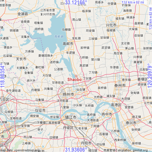
Shaobo GPS coordinates[2]
32° 31' 50.952" North, 119° 30' 23.976" East
| Map corner | latitude | longitude |
|---|---|---|
| Upper-left | 33.12166°, | 118.80354° |
| Center: | 32.53082°, | 119.50666° |
| Lower-right: | 31.93606°, | 120.20979° |
| Map W x H: | 131.8×131.8 km | = 81.9×81.9mi |
| max Lat: | 53.31946° ⇑35.9% North |
| Shaobo: | 32.53082° |
| min Lat: | ⇓64.1% South 18.22056° |
| min Long | Shaobo | max Long |
| 75.07348° | 119.50666° | 134.28917° |
| W 78.8%⇐ | ⇒21.2% E |
Elevation
Elevation of Shaobo is 9 m = 30 ft, and this is 475.8 m = 1561 ft below average elevation for this country.
| Max E: |
5622 m = 18445 ft | 91.2% |
| Avg. | 484.8 m = 1591 ft | |
| Shaobo | 9 m = 30 ft | |
Min E: |
-3 m = -10 ft | 8.8% |
See also: China elevation on elevation.city.
Geographical zone
Shaobo is located in North temperate zone (between Tropic of Cancer and the Arctic Circle). Distance of this Northern Tropic circle is 1011.2 km =628.3 mi to South.| Distance of | km | miles | from Shaobo |
|---|---|---|---|
| North Pole | 6390 | 3970.6 | to North |
| Arctic Circle | 3784.1 | 2351.3 | to North |
| Tropic Cancer | 1011.2 | 628.3 | to South |
| Equator | 3617.1 | 2247.6 | to South |


Nearby cities:
15 places around Shaobo: (largest is in red/bold)
• Chengbei
13.5 km =8.4 mi,  206°
206°
• Dinggou
15.1 km =9.4 mi,  75°
75°
• Dinghuo
9.5 km =5.9 mi,  95°
95°
• Fangxiang
11.7 km =7.3 mi,  255°
255°
• Ganquan
16.4 km =10.2 mi,  250°
250°
• Gongdao
16.2 km =10.1 mi,  293°
293°
• Pingshan
14.9 km =9.3 mi,  219°
219°
• Shouxihu
15.5 km =9.6 mi, 218°
• Tai’an
8.1 km =5 mi,  177°
177°
• Wantou
11.9 km =7.4 mi,  188°
188°
• Xiannü
12.5 km =7.8 mi,  156°
156°
• Xihu
15.7 km =9.8 mi, 222°
• Yangzhou
16.3 km =10.1 mi,  204°
204°
• Yiling
16.6 km =10.3 mi,  109°
109°
• Zhenwu
11.6 km =7.2 mi,  34°
34°
Sources, notices
• [Note1] Compared only with cities in China existing in our database
• [Src1] Map data: © OpenStreetMap contributors (CC-BY-SA)
• [Src2] Other city data from geonames.org with taken over terms of usage.
• [Src3] Geographical zone / Annual Mean Temperature by Robert A. Rohde @ Wikipedia
