Changlu geodata
Changlu (Jiangsu) is a seat of a fourth-order administrative division; located in China in Asia/Shanghai (GMT+8) time zone. In our database, there are 1268 cities with bigger population. Compared to other cities in China, 62.8% of cities are located further ↓South; 75% of cities are located further ←West and 77.2% of cities have higher elevation than Changlu. Note1


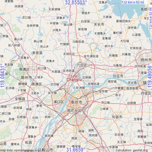
Changlu GPS coordinates[2]
32° 15' 44.676" North, 118° 47' 14.748" East
| Map corner | latitude | longitude |
|---|---|---|
| Upper-left | 32.85503°, | 118.08431° |
| Center: | 32.26241°, | 118.78743° |
| Lower-right: | 31.6659°, | 119.49056° |
| Map W x H: | 132.2×132.2 km | = 82.1×82.1mi |
| max Lat: | 53.31946° ⇑37.2% North |
| Changlu: | 32.26241° |
| min Lat: | ⇓62.8% South 18.22056° |
| min Long | Changlu | max Long |
| 75.07348° | 118.78743° | 134.28917° |
| W 75%⇐ | ⇒25% E |
Elevation
Elevation of Changlu is 32 m = 105 ft, and this is 452.8 m = 1486 ft below average elevation for this country.
| Max E: |
5622 m = 18445 ft | 77.2% |
| Avg. | 484.8 m = 1591 ft | |
| Changlu | 32 m = 105 ft | |
Min E: |
-3 m = -10 ft | 22.8% |
See also: China elevation on elevation.city.
Geographical zone
Changlu is located in North temperate zone (between Tropic of Cancer and the Arctic Circle). Distance of this Northern Tropic circle is 981.3 km =609.8 mi to South.| Distance of | km | miles | from Changlu |
|---|---|---|---|
| North Pole | 6419.8 | 3989.1 | to North |
| Arctic Circle | 3813.9 | 2369.8 | to North |
| Tropic Cancer | 981.3 | 609.8 | to South |
| Equator | 3587.2 | 2229 | to South |


Nearby cities:
15 places around Changlu: (largest is in red/bold)
• Baguazhou
10.3 km =6.4 mi,  164°
164°
• Chengqiao
15 km =9.3 mi,  336°
336°
• Getang
5.2 km =3.2 mi,  246°
246°
• Guabu
9.2 km =5.7 mi,  99°
99°
• Hongmiao
13.1 km =8.1 mi,  108°
108°
• Pancheng
9.3 km =5.8 mi,  233°
233°
• Shanpan
4.7 km =2.9 mi, 226°
• Taishan
14.7 km =9.1 mi,  212°
212°
• Xichangmen
5.1 km =3.2 mi, 212°
• Xiejiadian
7.2 km =4.5 mi,  217°
217°
• Xinji
8.5 km =5.3 mi,  306°
306°
• Xiongzhou
10.8 km =6.7 mi,  33°
33°
• Yanjiang
13.1 km =8.1 mi, 213°
• Yanziji
13.5 km =8.4 mi,  167°
167°
• Yudai
11.6 km =7.2 mi, 110°
Sources, notices
• [Note1] Compared only with cities in China existing in our database
• [Src1] Map data: © OpenStreetMap contributors (CC-BY-SA)
• [Src2] Other city data from geonames.org with taken over terms of usage.
• [Src3] Geographical zone / Annual Mean Temperature by Robert A. Rohde @ Wikipedia
