Gelin geodata
Gelin (Anhui) is a seat of a fourth-order administrative division; located in China in Asia/Shanghai (GMT+8) time zone. In our database, there are 1268 cities with bigger population. Compared to other cities in China, 53.7% of cities are located further ↓South; 72.4% of cities are located further ←West and 83.4% of cities have higher elevation than Gelin. Note1


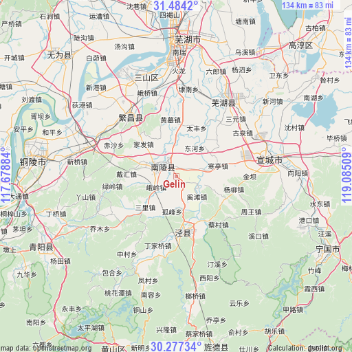
Gelin GPS coordinates[2]
30° 52' 57.612" North, 118° 22' 55.056" East
| Map corner | latitude | longitude |
|---|---|---|
| Upper-left | 31.4842°, | 117.67884° |
| Center: | 30.88267°, | 118.38196° |
| Lower-right: | 30.27734°, | 119.08509° |
| Map W x H: | 134.2×134.2 km | = 83.4×83.4mi |
| max Lat: | 53.31946° ⇑46.3% North |
| Gelin: | 30.88267° |
| min Lat: | ⇓53.7% South 18.22056° |
| min Long | Gelin | max Long |
| 75.07348° | 118.38196° | 134.28917° |
| W 72.4%⇐ | ⇒27.6% E |
Elevation
Elevation of Gelin is 19 m = 62 ft, and this is 465.8 m = 1528 ft below average elevation for this country.
| Max E: |
5622 m = 18445 ft | 83.4% |
| Avg. | 484.8 m = 1591 ft | |
| Gelin | 19 m = 62 ft | |
Min E: |
-3 m = -10 ft | 16.6% |
See also: China elevation on elevation.city.
Geographical zone
Gelin is located in North temperate zone (between Tropic of Cancer and the Arctic Circle). Distance of this Northern Tropic circle is 827.9 km =514.4 mi to South.| Distance of | km | miles | from Gelin |
|---|---|---|---|
| North Pole | 6573.2 | 4084.4 | to North |
| Arctic Circle | 3967.3 | 2465.2 | to North |
| Tropic Cancer | 827.9 | 514.4 | to South |
| Equator | 3433.8 | 2133.7 | to South |


Nearby cities:
15 places around Gelin: (largest is in red/bold)
• Changqiao
13.8 km =8.6 mi,  170°
170°
• Donghe
12.8 km =8 mi,  33°
33°
• Eling
8.7 km =5.4 mi,  241°
241°
• Gongshan
13.9 km =8.6 mi,  295°
295°
• Gufeng
13.5 km =8.4 mi,  186°
186°
• Hanting
16.4 km =10.2 mi,  75°
75°
• Jishan
6.6 km =4.1 mi,  311°
311°
• Jiulian
8.1 km =5 mi,  0°
0°
• Pingpu
15.3 km =9.5 mi,  337°
337°
• Sanli
17 km =10.6 mi,  225°
225°
• Shipu
3.6 km =2.2 mi, 2°
• Tongtuan
7.5 km =4.7 mi,  210°
210°
• Wenchang
10.5 km =6.5 mi, 76°
• Xihe
15 km =9.3 mi,  36°
36°
• Yijiang
10.3 km =6.4 mi,  74°
74°
Sources, notices
• [Note1] Compared only with cities in China existing in our database
• [Src1] Map data: © OpenStreetMap contributors (CC-BY-SA)
• [Src2] Other city data from geonames.org with taken over terms of usage.
• [Src3] Geographical zone / Annual Mean Temperature by Robert A. Rohde @ Wikipedia
