Gufeng geodata
Gufeng (Anhui) is a seat of a fourth-order administrative division; located in China in Asia/Shanghai (GMT+8) time zone. In our database, there are 1268 cities with bigger population. Compared to other cities in China, 52.6% of cities are located further ↓South; 72.3% of cities are located further ←West and 71.6% of cities have higher elevation than Gufeng. Note1


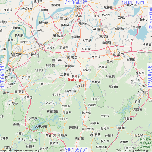
Gufeng GPS coordinates[2]
30° 45' 42.588" North, 118° 21' 53.388" East
| Map corner | latitude | longitude |
|---|---|---|
| Upper-left | 31.36412°, | 117.66171° |
| Center: | 30.76183°, | 118.36483° |
| Lower-right: | 30.15575°, | 119.06796° |
| Map W x H: | 134.4×134.4 km | = 83.5×83.5mi |
| max Lat: | 53.31946° ⇑47.4% North |
| Gufeng: | 30.76183° |
| min Lat: | ⇓52.6% South 18.22056° |
| min Long | Gufeng | max Long |
| 75.07348° | 118.36483° | 134.28917° |
| W 72.3%⇐ | ⇒27.7% E |
Elevation
Elevation of Gufeng is 46 m = 151 ft, and this is 438.8 m = 1440 ft below average elevation for this country.
| Max E: |
5622 m = 18445 ft | 71.6% |
| Avg. | 484.8 m = 1591 ft | |
| Gufeng | 46 m = 151 ft | |
Min E: |
-3 m = -10 ft | 28.4% |
See also: China elevation on elevation.city.
Geographical zone
Gufeng is located in North temperate zone (between Tropic of Cancer and the Arctic Circle). Distance of this Northern Tropic circle is 814.5 km =506.1 mi to South.| Distance of | km | miles | from Gufeng |
|---|---|---|---|
| North Pole | 6586.7 | 4092.8 | to North |
| Arctic Circle | 3980.8 | 2473.6 | to North |
| Tropic Cancer | 814.5 | 506.1 | to South |
| Equator | 3420.4 | 2125.3 | to South |


Nearby cities:
15 places around Gufeng: (largest is in red/bold)
• Beigong
18.2 km =11.3 mi,  240°
240°
• Changqiao
3.9 km =2.4 mi,  93°
93°
• Dingjiaqiao
14 km =8.7 mi,  202°
202°
• Eling
11 km =6.8 mi,  326°
326°
• Gelin
13.5 km =8.4 mi,  6°
6°
• Huangcun
17.4 km =10.8 mi,  191°
191°
• Jingchuan
8.9 km =5.5 mi,  154°
154°
• Jishan
18.1 km =11.2 mi,  349°
349°
• Qinxi
12.6 km =7.8 mi,  106°
106°
• Sanli
10.6 km =6.6 mi,  278°
278°
• Shipu
17.1 km =10.6 mi, 5°
• Taiyuan
6.6 km =4.1 mi, 148°
• Tongtuan
7.4 km =4.6 mi,  342°
342°
• Yangong
14.8 km =9.2 mi, 146°
• Yunling
18.1 km =11.2 mi,  228°
228°
Sources, notices
• [Note1] Compared only with cities in China existing in our database
• [Src1] Map data: © OpenStreetMap contributors (CC-BY-SA)
• [Src2] Other city data from geonames.org with taken over terms of usage.
• [Src3] Geographical zone / Annual Mean Temperature by Robert A. Rohde @ Wikipedia
