Chisha geodata
Chisha (Anhui) is a seat of a fourth-order administrative division; located in China in Asia/Shanghai (GMT+8) time zone. In our database, there are 1268 cities with bigger population. Compared to other cities in China, 54.7% of cities are located further ↓South; 71.2% of cities are located further ←West and 85.5% of cities have higher elevation than Chisha. Note1


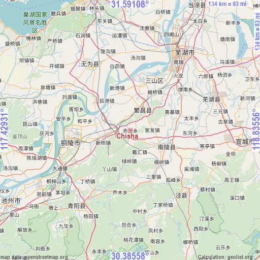
Chisha GPS coordinates[2]
30° 59' 24.828" North, 118° 7' 56.748" East
| Map corner | latitude | longitude |
|---|---|---|
| Upper-left | 31.59108°, | 117.42931° |
| Center: | 30.99023°, | 118.13243° |
| Lower-right: | 30.38558°, | 118.83556° |
| Map W x H: | 134×134 km | = 83.3×83.3mi |
| max Lat: | 53.31946° ⇑45.3% North |
| Chisha: | 30.99023° |
| min Lat: | ⇓54.7% South 18.22056° |
| min Long | Chisha | max Long |
| 75.07348° | 118.13243° | 134.28917° |
| W 71.2%⇐ | ⇒28.8% E |
Elevation
Elevation of Chisha is 15 m = 49 ft, and this is 469.8 m = 1541 ft below average elevation for this country.
| Max E: |
5622 m = 18445 ft | 85.5% |
| Avg. | 484.8 m = 1591 ft | |
| Chisha | 15 m = 49 ft | |
Min E: |
-3 m = -10 ft | 14.5% |
See also: China elevation on elevation.city.
Geographical zone
Chisha is located in North temperate zone (between Tropic of Cancer and the Arctic Circle). Distance of this Northern Tropic circle is 839.9 km =521.9 mi to South.| Distance of | km | miles | from Chisha |
|---|---|---|---|
| North Pole | 6561.3 | 4077 | to North |
| Arctic Circle | 3955.4 | 2457.8 | to North |
| Tropic Cancer | 839.9 | 521.9 | to South |
| Equator | 3445.8 | 2141.1 | to South |


Nearby cities:
15 places around Chisha: (largest is in red/bold)
• Daihui
12.1 km =7.5 mi,  156°
156°
• Digang
19.6 km =12.2 mi,  321°
321°
• Eling
22.8 km =14.2 mi,  134°
134°
• Eshan
11.4 km =7.1 mi,  43°
43°
• Fanyang
12 km =7.5 mi,  29°
29°
• Gongshan
12.8 km =8 mi,  118°
118°
• Hewan
20 km =12.4 mi,  194°
194°
• Huangmu
23.6 km =14.7 mi,  65°
65°
• Jiafa
11.3 km =7 mi,  88°
88°
• Jishan
20.3 km =12.6 mi,  112°
112°
• Lüling
15.7 km =9.8 mi,  182°
182°
• Pingpu
18.2 km =11.3 mi,  83°
83°
• Wenwucao
8 km =5 mi,  195°
195°
• Yashan
22.2 km =13.8 mi,  209°
209°
• Zhongming
7.8 km =4.8 mi,  265°
265°
Sources, notices
• [Note1] Compared only with cities in China existing in our database
• [Src1] Map data: © OpenStreetMap contributors (CC-BY-SA)
• [Src2] Other city data from geonames.org with taken over terms of usage.
• [Src3] Geographical zone / Annual Mean Temperature by Robert A. Rohde @ Wikipedia
