San Miguel geodata
San Miguel (Santander) is a seat of a second-order administrative division; located in Colombia in America/Bogota (GMT-5) time zone. With population of 624 people, there are 1012 cities with bigger population in this country. Compared to other cities in Colombia, 69.6% of cities are located further ↓South; 93.6% of cities are located further ←West and 77.3% of cities have lower elevation than San Miguel. Note1


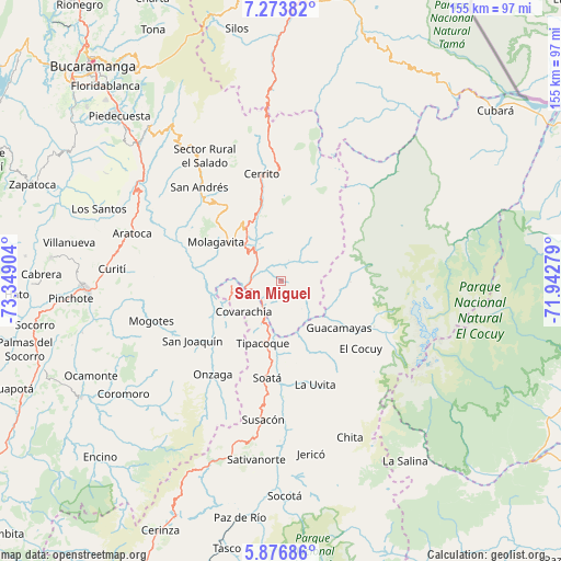
San Miguel GPS coordinates[2]
6° 34' 32.988" North, 72° 38' 45.276" West
| Map corner | latitude | longitude |
|---|---|---|
| Upper-left | 7.27382°, | -73.34904° |
| Center: | 6.57583°, | -72.64591° |
| Lower-right: | 5.87686°, | -71.94279° |
| Map W x H: | 155.3×155.3 km | = 96.5×96.5mi |
| max Lat: | 13.38166° ⇑30.4% North |
| San Miguel: | 6.57583° |
| min Lat: | ⇓69.6% South -4.21528° |
| min Long | San Miguel | max Long |
| -81.70636° | -72.64591° | -67.06996° |
| W 93.6%⇐ | ⇒6.4% E |
Elevation
Elevation of San Miguel is 1926 m = 6319 ft, and this is 776.7 m = 2548 ft above average elevation for this country.
| Max E: |
3342 m = 10965 ft | 22.7% |
| San Miguel | 1926 m 6319 ft | |
| Avg. | 1149.3 m = 3771 ft | |
Min E: |
1 m = 3 ft | 77.3% |
See also: Colombia elevation on elevation.city.
Geographical zone
San Miguel is located in North Torrid zone (between Equator and Tropic of Cancer). Distance of Equator is 731.2 km =454.3 mi to South.| Distance of | km | miles | from San Miguel |
|---|---|---|---|
| North Pole | 9275.9 | 5763.8 | to North |
| Arctic Circle | 6670 | 4144.5 | to North |
| Tropic Cancer | 1874.8 | 1164.9 | to North |
| Equator | 731.2 | 454.3 | to South |


Nearby cities:
15 places around San Miguel: (largest is in red/bold)
• Capitanejo
7.6 km =4.7 mi,  226°
226°
• Carcasí
6.1 km =3.8 mi,  20°
20°
• Chiscas
15.8 km =9.8 mi,  97°
97°
• Concepción
21.8 km =13.5 mi,  345°
345°
• Covarachía
12.4 km =7.7 mi, 230°
• El Espino
19.4 km =12.1 mi,  122°
122°
• El Peñón
20.9 km =13 mi,  262°
262°
• Enciso
11.9 km =7.4 mi,  329°
329°
• Guacamayas
20.1 km =12.5 mi,  128°
128°
• Macaravita
9.7 km =6 mi,  143°
143°
• Molagavita
21 km =13 mi,  301°
301°
• Málaga
16.7 km =10.4 mi, 325°
• San José de Miranda
13.4 km =8.3 mi,  313°
313°
• San Mateo
21.9 km =13.6 mi,  152°
152°
• Tipacoque
18 km =11.2 mi,  196°
196°
Sources, notices
• [Note1] Compared only with cities in Colombia existing in our database
• [Src1] Map data: © OpenStreetMap contributors (CC-BY-SA)
• [Src2] Other city data from geonames.org with taken over terms of usage.
• [Src3] Geographical zone / Annual Mean Temperature by Robert A. Rohde @ Wikipedia
