San Mateo geodata
San Mateo (Boyacá) is a seat of a second-order administrative division; located in Colombia in America/Bogota (GMT-5) time zone. With population of 1,634 people, there are 848 cities with bigger population in this country. Compared to other cities in Colombia, 66.3% of cities are located further ↓South; 95% of cities are located further ←West and 84.3% of cities have lower elevation than San Mateo. Note1


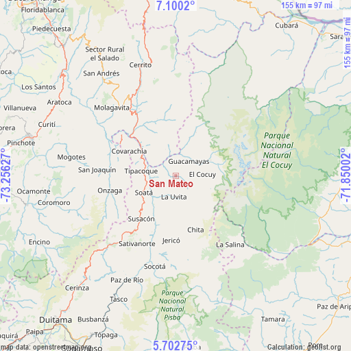
San Mateo GPS coordinates[2]
6° 24' 7.02" North, 72° 33' 11.304" West
| Map corner | latitude | longitude |
|---|---|---|
| Upper-left | 7.1002°, | -73.25627° |
| Center: | 6.40195°, | -72.55314° |
| Lower-right: | 5.70275°, | -71.85002° |
| Map W x H: | 155.4×155.4 km | = 96.6×96.6mi |
| max Lat: | 13.38166° ⇑33.7% North |
| San Mateo: | 6.40195° |
| min Lat: | ⇓66.3% South -4.21528° |
| min Long | San Mateo | max Long |
| -81.70636° | -72.55314° | -67.06996° |
| W 95%⇐ | ⇒5% E |
Elevation
Elevation of San Mateo is 2223 m = 7293 ft, and this is 1073.7 m = 3523 ft above average elevation for this country.
| Max E: |
3342 m = 10965 ft | 15.7% |
| San Mateo | 2223 m 7293 ft | |
| Avg. | 1149.3 m = 3771 ft | |
Min E: |
1 m = 3 ft | 84.3% |
See also: Colombia elevation on elevation.city.
Geographical zone
San Mateo is located in North Torrid zone (between Equator and Tropic of Cancer). Distance of Equator is 711.8 km =442.3 mi to South.| Distance of | km | miles | from San Mateo |
|---|---|---|---|
| North Pole | 9295.2 | 5775.8 | to North |
| Arctic Circle | 6689.3 | 4156.5 | to North |
| Tropic Cancer | 1894.1 | 1176.9 | to North |
| Equator | 711.8 | 442.3 | to South |


Nearby cities:
15 places around San Mateo: (largest is in red/bold)
• Boavita
8.7 km =5.4 mi,  203°
203°
• Capitanejo
21.2 km =13.2 mi,  311°
311°
• Chiscas
18 km =11.2 mi,  17°
17°
• Covarachía
23 km =14.3 mi,  300°
300°
• El Cocuy
11.6 km =7.2 mi,  84°
84°
• El Espino
10.9 km =6.8 mi,  34°
34°
• Guacamayas
8.6 km =5.3 mi,  38°
38°
• Güicán
16.8 km =10.4 mi,  65°
65°
• La Uvita
9.1 km =5.7 mi,  186°
186°
• Macaravita
12.3 km =7.6 mi,  339°
339°
• Panqueba
11.1 km =6.9 mi,  64°
64°
• San Miguel
21.9 km =13.6 mi,  332°
332°
• Soatá
16.2 km =10.1 mi,  242°
242°
• Susacón
24.4 km =15.2 mi,  218°
218°
• Tipacoque
15.5 km =9.6 mi,  277°
277°
Sources, notices
• [Note1] Compared only with cities in Colombia existing in our database
• [Src1] Map data: © OpenStreetMap contributors (CC-BY-SA)
• [Src2] Other city data from geonames.org with taken over terms of usage.
• [Src3] Geographical zone / Annual Mean Temperature by Robert A. Rohde @ Wikipedia
