El Peñón geodata
El Peñón (Santander) is a populated place; located in Colombia in America/Bogota (GMT-5) time zone. With population of 831 people, there are 972 cities with bigger population in this country. Compared to other cities in Colombia, 69% of cities are located further ↓South; 89.9% of cities are located further ←West and 54.5% of cities have higher elevation than El Peñón. Note1


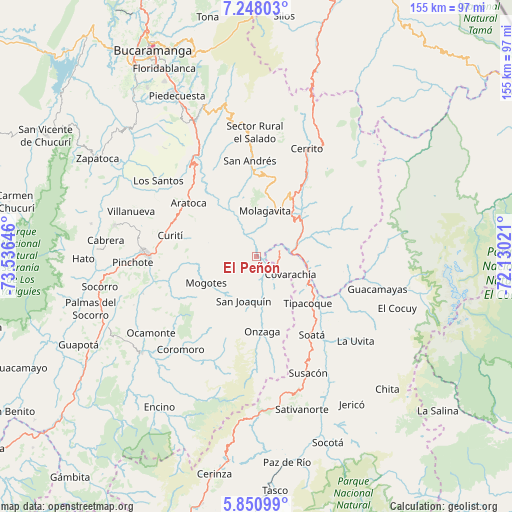
El Peñón GPS coordinates[2]
6° 33' 0" North, 72° 49' 59.988" West
| Map corner | latitude | longitude |
|---|---|---|
| Upper-left | 7.24803°, | -73.53646° |
| Center: | 6.55°, | -72.83333° |
| Lower-right: | 5.85099°, | -72.13021° |
| Map W x H: | 155.3×155.3 km | = 96.5×96.5mi |
| max Lat: | 13.38166° ⇑31% North |
| El Peñón: | 6.55° |
| min Lat: | ⇓69% South -4.21528° |
| min Long | El Peñón | max Long |
| -81.70636° | -72.83333° | -67.06996° |
| W 89.9%⇐ | ⇒10.1% E |
Elevation
Elevation of El Peñón is 981 m = 3219 ft, and this is 168.3 m = 552 ft below average elevation for this country.
| Max E: |
3342 m = 10965 ft | 54.5% |
| Avg. | 1149.3 m = 3771 ft | |
| El Peñón | 981 m = 3219 ft | |
Min E: |
1 m = 3 ft | 45.5% |
See also: Colombia elevation on elevation.city.
Geographical zone
El Peñón is located in North Torrid zone (between Equator and Tropic of Cancer). Distance of Equator is 728.3 km =452.5 mi to South.| Distance of | km | miles | from El Peñón |
|---|---|---|---|
| North Pole | 9278.8 | 5765.6 | to North |
| Arctic Circle | 6672.9 | 4146.3 | to North |
| Tropic Cancer | 1877.6 | 1166.7 | to North |
| Equator | 728.3 | 452.5 | to South |


Nearby cities:
15 places around El Peñón: (largest is in red/bold)
• Aratoca
26 km =16.2 mi,  308°
308°
• Capitanejo
15.4 km =9.6 mi,  98°
98°
• Carcasí
24.4 km =15.2 mi,  69°
69°
• Covarachía
12.1 km =7.5 mi,  114°
114°
• Curití
26.6 km =16.5 mi,  283°
283°
• Enciso
19.7 km =12.2 mi,  48°
48°
• Macaravita
27 km =16.8 mi, 100°
• Mogotes
17.3 km =10.7 mi,  241°
241°
• Molagavita
14 km =8.7 mi,  11°
11°
• Málaga
20 km =12.4 mi,  33°
33°
• Onzaga
22.9 km =14.2 mi,  175°
175°
• San Joaquín
13.9 km =8.6 mi,  195°
195°
• San José de Miranda
16.4 km =10.2 mi,  42°
42°
• San Miguel
20.9 km =13 mi,  82°
82°
• Tipacoque
21.3 km =13.2 mi,  132°
132°
Sources, notices
• [Note1] Compared only with cities in Colombia existing in our database
• [Src1] Map data: © OpenStreetMap contributors (CC-BY-SA)
• [Src2] Other city data from geonames.org with taken over terms of usage.
• [Src3] Geographical zone / Annual Mean Temperature by Robert A. Rohde @ Wikipedia
