San Lorenzo geodata
San Lorenzo (Nariño) is a seat of a second-order administrative division; located in Colombia in America/Bogota (GMT-5) time zone. With population of 2,394 people, there are 751 cities with bigger population in this country. Compared to other cities in Colombia, 93.5% of cities are located further ↑North; 94% of cities are located further →East and 86.2% of cities have lower elevation than San Lorenzo. Note1


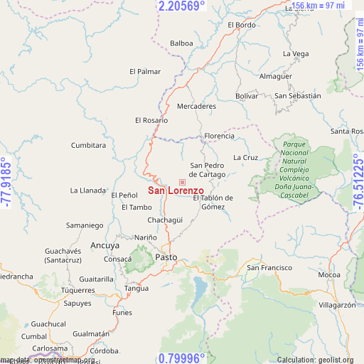
San Lorenzo GPS coordinates[2]
1° 30' 10.584" North, 77° 12' 55.332" West
| Map corner | latitude | longitude |
|---|---|---|
| Upper-left | 2.20569°, | -77.9185° |
| Center: | 1.50294°, | -77.21537° |
| Lower-right: | 0.79996°, | -76.51225° |
| Map W x H: | 156.3×156.3 km | = 97.1×97.1mi |
| max Lat: | 13.38166° ⇑93.5% North |
| San Lorenzo: | 1.50294° |
| min Lat: | ⇓6.5% South -4.21528° |
| min Long | San Lorenzo | max Long |
| -81.70636° | -77.21537° | -67.06996° |
| W 6%⇐ | ⇒94% E |
Elevation
Elevation of San Lorenzo is 2365 m = 7759 ft, and this is 1215.7 m = 3989 ft above average elevation for this country.
| Max E: |
3342 m = 10965 ft | 13.8% |
| San Lorenzo | 2365 m 7759 ft | |
| Avg. | 1149.3 m = 3771 ft | |
Min E: |
1 m = 3 ft | 86.2% |
See also: Colombia elevation on elevation.city.
Geographical zone
San Lorenzo is located in North Torrid zone (between Equator and Tropic of Cancer). Distance of Equator is 167.1 km =103.8 mi to South.| Distance of | km | miles | from San Lorenzo |
|---|---|---|---|
| North Pole | 9840 | 6114.3 | to North |
| Arctic Circle | 7234.1 | 4495.1 | to North |
| Tropic Cancer | 2438.8 | 1515.4 | to North |
| Equator | 167.1 | 103.8 | to South |


Nearby cities:
15 places around San Lorenzo: (largest is in red/bold)
• Arboleda
8.9 km =5.5 mi,  93°
93°
• Belén
20.6 km =12.8 mi,  60°
60°
• Buesaco
14.8 km =9.2 mi,  153°
153°
• Cartago
11.9 km =7.4 mi, 63°
• Chachagüí
17.7 km =11 mi,  205°
205°
• El Peñol
25.6 km =15.9 mi,  257°
257°
• El Tablón
15.6 km =9.7 mi,  122°
122°
• El Tambo
22.3 km =13.9 mi,  241°
241°
• Florencia
25.5 km =15.8 mi,  38°
38°
• Génova
26.8 km =16.7 mi,  54°
54°
• La Unión
14.6 km =9.1 mi, 39°
• San Bernardo
18.8 km =11.7 mi, 85°
• San José
15.2 km =9.4 mi,  102°
102°
• Santacruz
5.6 km =3.5 mi,  291°
291°
• Taminango
10.4 km =6.5 mi,  316°
316°
Sources, notices
• [Note1] Compared only with cities in Colombia existing in our database
• [Src1] Map data: © OpenStreetMap contributors (CC-BY-SA)
• [Src2] Other city data from geonames.org with taken over terms of usage.
• [Src3] Geographical zone / Annual Mean Temperature by Robert A. Rohde @ Wikipedia
