Belén geodata
Belén (Nariño) is a populated place; located in Colombia in America/Bogota (GMT-5) time zone. With population of 3,131 people, there are 669 cities with bigger population in this country. Compared to other cities in Colombia, 92.9% of cities are located further ↑North; 93.1% of cities are located further →East and 85.8% of cities have lower elevation than Belén. Note1


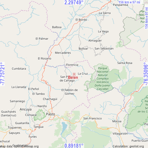
Belén GPS coordinates[2]
1° 35' 41.172" North, 77° 3' 14.688" West
| Map corner | latitude | longitude |
|---|---|---|
| Upper-left | 2.29749°, | -77.75721° |
| Center: | 1.59477°, | -77.05408° |
| Lower-right: | 0.89181°, | -76.35096° |
| Map W x H: | 156.3×156.3 km | = 97.1×97.1mi |
| max Lat: | 13.38166° ⇑92.9% North |
| Belén: | 1.59477° |
| min Lat: | ⇓7.1% South -4.21528° |
| min Long | Belén | max Long |
| -81.70636° | -77.05408° | -67.06996° |
| W 6.9%⇐ | ⇒93.1% E |
Elevation
Elevation of Belén is 2331 m = 7648 ft, and this is 1181.7 m = 3877 ft above average elevation for this country.
| Max E: |
3342 m = 10965 ft | 14.2% |
| Belén | 2331 m 7648 ft | |
| Avg. | 1149.3 m = 3771 ft | |
Min E: |
1 m = 3 ft | 85.8% |
See also: Colombia elevation on elevation.city.
Geographical zone
Belén is located in North Torrid zone (between Equator and Tropic of Cancer). Distance of Equator is 177.3 km =110.2 mi to South.| Distance of | km | miles | from Belén |
|---|---|---|---|
| North Pole | 9829.7 | 6107.9 | to North |
| Arctic Circle | 7223.9 | 4488.7 | to North |
| Tropic Cancer | 2428.6 | 1509.1 | to North |
| Equator | 177.3 | 110.2 | to South |


Nearby cities:
15 places around Belén: (largest is in red/bold)
• Arboleda
14.1 km =8.8 mi,  220°
220°
• Buesaco
26.1 km =16.2 mi,  205°
205°
• Cartago
8.7 km =5.4 mi,  236°
236°
• El Tablón
19.2 km =11.9 mi,  194°
194°
• Florencia
10.1 km =6.3 mi,  347°
347°
• Génova
6.7 km =4.2 mi,  35°
35°
• La Cruz
9.2 km =5.7 mi,  84°
84°
• La Unión
8.7 km =5.4 mi,  277°
277°
• Mercaderes
26.4 km =16.4 mi,  330°
330°
• San Bernardo
8.9 km =5.5 mi,  174°
174°
• San José
13.7 km =8.5 mi, 192°
• San Lorenzo
20.6 km =12.8 mi, 240°
• San Pablo
9.7 km =6 mi,  27°
27°
• Santacruz
24.5 km =15.2 mi,  250°
250°
• Taminango
25.3 km =15.7 mi,  263°
263°
Sources, notices
• [Note1] Compared only with cities in Colombia existing in our database
• [Src1] Map data: © OpenStreetMap contributors (CC-BY-SA)
• [Src2] Other city data from geonames.org with taken over terms of usage.
• [Src3] Geographical zone / Annual Mean Temperature by Robert A. Rohde @ Wikipedia
