Florencia geodata
Florencia (Cauca) is a seat of a second-order administrative division; located in Colombia in America/Bogota (GMT-5) time zone. With population of 1,467 people, there are 870 cities with bigger population in this country. Compared to other cities in Colombia, 92% of cities are located further ↑North; 93.2% of cities are located further →East and 65.8% of cities have lower elevation than Florencia. Note1


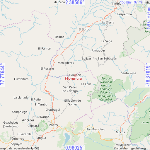
Florencia GPS coordinates[2]
1° 40' 59.448" North, 77° 4' 23.916" West
| Map corner | latitude | longitude |
|---|---|---|
| Upper-left | 2.38586°, | -77.77644° |
| Center: | 1.68318°, | -77.07331° |
| Lower-right: | 0.98025°, | -76.37019° |
| Map W x H: | 156.3×156.3 km | = 97.1×97.1mi |
| max Lat: | 13.38166° ⇑92% North |
| Florencia: | 1.68318° |
| min Lat: | ⇓8% South -4.21528° |
| min Long | Florencia | max Long |
| -81.70636° | -77.07331° | -67.06996° |
| W 6.8%⇐ | ⇒93.2% E |
Elevation
Elevation of Florencia is 1611 m = 5285 ft, and this is 461.7 m = 1515 ft above average elevation for this country.
| Max E: |
3342 m = 10965 ft | 34.2% |
| Florencia | 1611 m 5285 ft | |
| Avg. | 1149.3 m = 3771 ft | |
Min E: |
1 m = 3 ft | 65.8% |
See also: Colombia elevation on elevation.city.
Geographical zone
Florencia is located in North Torrid zone (between Equator and Tropic of Cancer). Distance of Equator is 187.2 km =116.3 mi to South.| Distance of | km | miles | from Florencia |
|---|---|---|---|
| North Pole | 9819.9 | 6101.8 | to North |
| Arctic Circle | 7214 | 4482.6 | to North |
| Tropic Cancer | 2418.8 | 1503 | to North |
| Equator | 187.2 | 116.3 | to South |


Nearby cities:
15 places around Florencia: (largest is in red/bold)
• Arboleda
21.8 km =13.5 mi,  198°
198°
• Belén
10.1 km =6.3 mi,  167°
167°
• Bolívar
20.9 km =13 mi,  33°
33°
• Cartago
15.5 km =9.6 mi, 199°
• El Tablón
28.6 km =17.8 mi,  185°
185°
• Génova
7.4 km =4.6 mi,  126°
126°
• La Cruz
14.5 km =9 mi, 128°
• La Unión
10.9 km =6.8 mi,  216°
216°
• Mercaderes
17 km =10.6 mi,  320°
320°
• San Bernardo
18.9 km =11.7 mi, 171°
• San José
23.2 km =14.4 mi,  182°
182°
• San Lorenzo
25.5 km =15.8 mi, 218°
• San Pablo
6.7 km =4.2 mi,  100°
100°
• Santacruz
27.7 km =17.2 mi,  229°
229°
• Taminango
26.2 km =16.3 mi,  241°
241°
Sources, notices
• [Note1] Compared only with cities in Colombia existing in our database
• [Src1] Map data: © OpenStreetMap contributors (CC-BY-SA)
• [Src2] Other city data from geonames.org with taken over terms of usage.
• [Src3] Geographical zone / Annual Mean Temperature by Robert A. Rohde @ Wikipedia
