Pulí geodata
Pulí (Cundinamarca) is a seat of a second-order administrative division; located in Colombia in America/Bogota (GMT-5) time zone. With population of 596 people, there are 1015 cities with bigger population in this country. Compared to other cities in Colombia, 68.6% of cities are located further ↑North; 53.1% of cities are located further ←West and 54.8% of cities have lower elevation than Pulí. Note1


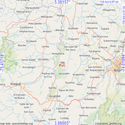
Pulí GPS coordinates[2]
4° 40' 52.176" North, 74° 42' 50.616" West
| Map corner | latitude | longitude |
|---|---|---|
| Upper-left | 5.38157°, | -75.41719° |
| Center: | 4.68116°, | -74.71406° |
| Lower-right: | 3.98005°, | -74.01094° |
| Map W x H: | 155.8×155.8 km | = 96.8×96.8mi |
| max Lat: | 13.38166° ⇑68.6% North |
| Pulí: | 4.68116° |
| min Lat: | ⇓31.4% South -4.21528° |
| min Long | Pulí | max Long |
| -81.70636° | -74.71406° | -67.06996° |
| W 53.1%⇐ | ⇒46.9% E |
Elevation
Elevation of Pulí is 1287 m = 4222 ft, and this is 137.7 m = 452 ft above average elevation for this country.
| Max E: |
3342 m = 10965 ft | 45.2% |
| Pulí | 1287 m 4222 ft | |
| Avg. | 1149.3 m = 3771 ft | |
Min E: |
1 m = 3 ft | 54.8% |
See also: Colombia elevation on elevation.city.
Geographical zone
Pulí is located in North Torrid zone (between Equator and Tropic of Cancer). Distance of Equator is 520.5 km =323.4 mi to South.| Distance of | km | miles | from Pulí |
|---|---|---|---|
| North Pole | 9486.6 | 5894.7 | to North |
| Arctic Circle | 6880.7 | 4275.5 | to North |
| Tropic Cancer | 2085.4 | 1295.8 | to North |
| Equator | 520.5 | 323.4 | to South |


Nearby cities:
15 places around Pulí: (largest is in red/bold)
• Alvarado
29.2 km =18.1 mi,  244°
244°
• Ambalema
12.6 km =7.8 mi,  334°
334°
• Anapoima
24.5 km =15.2 mi,  126°
126°
• Anolaima
29.2 km =18.1 mi,  54°
54°
• Apulo
22.4 km =13.9 mi,  143°
143°
• Beltrán
13.7 km =8.5 mi,  347°
347°
• Bituima
28.8 km =17.9 mi,  42°
42°
• Guataquí
20.2 km =12.6 mi,  204°
204°
• Jerusalén
13.3 km =8.3 mi,  170°
170°
• Piedras
23.8 km =14.8 mi,  229°
229°
• Quipile
21.2 km =13.2 mi,  70°
70°
• San Juan de Rioseco
21.2 km =13.2 mi,  28°
28°
• Tocaima
26.3 km =16.3 mi,  160°
160°
• Venadillo
24.2 km =15 mi,  280°
280°
• Vianí
27.2 km =16.9 mi, 38°
Sources, notices
• [Note1] Compared only with cities in Colombia existing in our database
• [Src1] Map data: © OpenStreetMap contributors (CC-BY-SA)
• [Src2] Other city data from geonames.org with taken over terms of usage.
• [Src3] Geographical zone / Annual Mean Temperature by Robert A. Rohde @ Wikipedia
