Guataquí geodata
Guataquí (Cundinamarca) is a seat of a second-order administrative division; located in Colombia in America/Bogota (GMT-5) time zone. With population of 1,139 people, there are 925 cities with bigger population in this country. Compared to other cities in Colombia, 71.3% of cities are located further ↑North; 50.8% of cities are located further ←West and 71.9% of cities have higher elevation than Guataquí. Note1


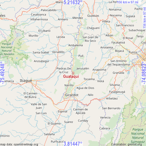
Guataquí GPS coordinates[2]
4° 30' 56.628" North, 74° 47' 21.66" West
| Map corner | latitude | longitude |
|---|---|---|
| Upper-left | 5.21632°, | -75.49248° |
| Center: | 4.51573°, | -74.78935° |
| Lower-right: | 3.81447°, | -74.08623° |
| Map W x H: | 155.9×155.9 km | = 96.9×96.9mi |
| max Lat: | 13.38166° ⇑71.3% North |
| Guataquí: | 4.51573° |
| min Lat: | ⇓28.7% South -4.21528° |
| min Long | Guataquí | max Long |
| -81.70636° | -74.78935° | -67.06996° |
| W 50.8%⇐ | ⇒49.2% E |
Elevation
Elevation of Guataquí is 255 m = 837 ft, and this is 894.3 m = 2934 ft below average elevation for this country.
| Max E: |
3342 m = 10965 ft | 71.9% |
| Avg. | 1149.3 m = 3771 ft | |
| Guataquí | 255 m = 837 ft | |
Min E: |
1 m = 3 ft | 28.1% |
See also: Colombia elevation on elevation.city.
Geographical zone
Guataquí is located in North Torrid zone (between Equator and Tropic of Cancer). Distance of Equator is 502.1 km =312 mi to South.| Distance of | km | miles | from Guataquí |
|---|---|---|---|
| North Pole | 9505 | 5906.1 | to North |
| Arctic Circle | 6899.1 | 4286.9 | to North |
| Tropic Cancer | 2103.8 | 1307.2 | to North |
| Equator | 502.1 | 312 | to South |


Nearby cities:
15 places around Guataquí: (largest is in red/bold)
• Agua de Dios
20.4 km =12.7 mi,  139°
139°
• Alvarado
19 km =11.8 mi,  287°
287°
• Anapoima
28.4 km =17.6 mi,  82°
82°
• Apulo
21.8 km =13.5 mi,  88°
88°
• Coello
27.9 km =17.3 mi,  205°
205°
• Doima
22.9 km =14.2 mi,  244°
244°
• Flandes
25.3 km =15.7 mi,  186°
186°
• Girardot City
24 km =14.9 mi,  184°
184°
• Jerusalén
11.7 km =7.3 mi,  63°
63°
• Nariño
13.8 km =8.6 mi,  197°
197°
• Piedras
10.3 km =6.4 mi, 286°
• Pulí
20.2 km =12.6 mi,  24°
24°
• Ricaurte
26.3 km =16.3 mi,  174°
174°
• Tocaima
18.3 km =11.4 mi,  110°
110°
• Venadillo
27.4 km =17 mi,  325°
325°
Sources, notices
• [Note1] Compared only with cities in Colombia existing in our database
• [Src1] Map data: © OpenStreetMap contributors (CC-BY-SA)
• [Src2] Other city data from geonames.org with taken over terms of usage.
• [Src3] Geographical zone / Annual Mean Temperature by Robert A. Rohde @ Wikipedia
