Alvarado geodata
Alvarado (Tolima) is a seat of a second-order administrative division; located in Colombia in America/Bogota (GMT-5) time zone. With population of 2,049 people, there are 792 cities with bigger population in this country. Compared to other cities in Colombia, 70.2% of cities are located further ↑North; 52.9% of cities are located further →East and 65.9% of cities have higher elevation than Alvarado. Note1


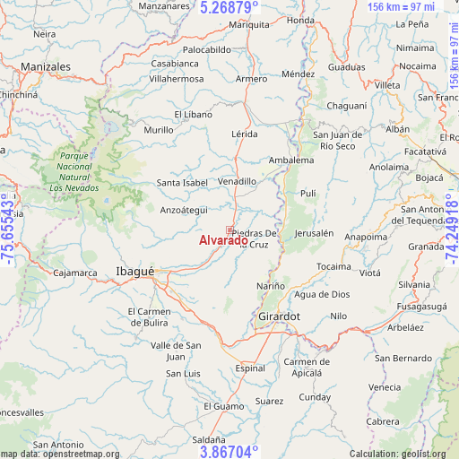
Alvarado GPS coordinates[2]
4° 34' 5.736" North, 74° 57' 8.28" West
| Map corner | latitude | longitude |
|---|---|---|
| Upper-left | 5.26879°, | -75.65543° |
| Center: | 4.56826°, | -74.9523° |
| Lower-right: | 3.86704°, | -74.24918° |
| Map W x H: | 155.9×155.9 km | = 96.9×96.9mi |
| max Lat: | 13.38166° ⇑70.2% North |
| Alvarado: | 4.56826° |
| min Lat: | ⇓29.8% South -4.21528° |
| min Long | Alvarado | max Long |
| -81.70636° | -74.9523° | -67.06996° |
| W 47.1%⇐ | ⇒52.9% E |
Elevation
Elevation of Alvarado is 412 m = 1352 ft, and this is 737.3 m = 2419 ft below average elevation for this country.
| Max E: |
3342 m = 10965 ft | 65.9% |
| Avg. | 1149.3 m = 3771 ft | |
| Alvarado | 412 m = 1352 ft | |
Min E: |
1 m = 3 ft | 34.1% |
See also: Colombia elevation on elevation.city.
Geographical zone
Alvarado is located in North Torrid zone (between Equator and Tropic of Cancer). Distance of Equator is 507.9 km =315.6 mi to South.| Distance of | km | miles | from Alvarado |
|---|---|---|---|
| North Pole | 9499.1 | 5902.5 | to North |
| Arctic Circle | 6893.2 | 4283.2 | to North |
| Tropic Cancer | 2098 | 1303.6 | to North |
| Equator | 507.9 | 315.6 | to South |


Nearby cities:
15 places around Alvarado: (largest is in red/bold)
• Ambalema
31.9 km =19.8 mi,  41°
41°
• Anzoátegui
17.2 km =10.7 mi,  293°
293°
• Coello
31.6 km =19.6 mi,  169°
169°
• Doima
15.9 km =9.9 mi,  189°
189°
• Girardot City
33.8 km =21 mi,  151°
151°
• Guataquí
19 km =11.8 mi,  107°
107°
• Jerusalén
28.5 km =17.7 mi,  91°
91°
• Junín
25 km =15.5 mi,  343°
343°
• Lérida
33 km =20.5 mi,  8°
8°
• Nariño
23.5 km =14.6 mi,  143°
143°
• Payandé
34.1 km =21.2 mi,  207°
207°
• Piedras
8.7 km =5.4 mi, 109°
• Pulí
29.2 km =18.1 mi,  64°
64°
• Santa Isabel
22.9 km =14.2 mi,  315°
315°
• Venadillo
17 km =10.6 mi, 8°
Sources, notices
• [Note1] Compared only with cities in Colombia existing in our database
• [Src1] Map data: © OpenStreetMap contributors (CC-BY-SA)
• [Src2] Other city data from geonames.org with taken over terms of usage.
• [Src3] Geographical zone / Annual Mean Temperature by Robert A. Rohde @ Wikipedia
