Palmira geodata
Palmira (Valle del Cauca) is a seat of a second-order administrative division; located in Colombia in America/Bogota (GMT-5) time zone. With population of 247,986 people, there are 24 cities with bigger population in this country. Compared to other cities in Colombia, 81.3% of cities are located further ↑North; 84.5% of cities are located further →East and 53.2% of cities have higher elevation than Palmira. Note1


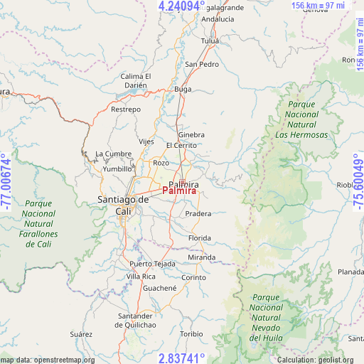
Palmira GPS coordinates[2]
3° 32' 21.984" North, 76° 18' 12.996" West
| Map corner | latitude | longitude |
|---|---|---|
| Upper-left | 4.24094°, | -77.00674° |
| Center: | 3.53944°, | -76.30361° |
| Lower-right: | 2.83741°, | -75.60049° |
| Map W x H: | 156.1×156.1 km | = 97×97mi |
| max Lat: | 13.38166° ⇑81.3% North |
| Palmira: | 3.53944° |
| min Lat: | ⇓18.7% South -4.21528° |
| min Long | Palmira | max Long |
| -81.70636° | -76.30361° | -67.06996° |
| W 15.5%⇐ | ⇒84.5% E |
Elevation
Elevation of Palmira is 1005 m = 3297 ft, and this is 144.3 m = 473 ft below average elevation for this country.
| Max E: |
3342 m = 10965 ft | 53.2% |
| Avg. | 1149.3 m = 3771 ft | |
| Palmira | 1005 m = 3297 ft | |
Min E: |
1 m = 3 ft | 46.8% |
See also: Palmira elevation on elevation.city.
Geographical zone
Palmira is located in North Torrid zone (between Equator and Tropic of Cancer). Distance of Equator is 393.5 km =244.5 mi to South.| Distance of | km | miles | from Palmira |
|---|---|---|---|
| North Pole | 9613.5 | 5973.6 | to North |
| Arctic Circle | 7007.6 | 4354.3 | to North |
| Tropic Cancer | 2212.4 | 1374.7 | to North |
| Equator | 393.5 | 244.5 | to South |


Nearby cities:
15 places around Palmira: (largest is in red/bold)
• Cali
26.8 km =16.7 mi,  244°
244°
• Candelaria
15.6 km =9.7 mi,  198°
198°
• El Cerrito
16.3 km =10.1 mi,  356°
356°
• Florida
25.3 km =15.7 mi,  162°
162°
• Ginebra
21 km =13 mi,  11°
11°
• Guacarí
25.2 km =15.7 mi,  352°
352°
• La Cumbre
32 km =19.9 mi,  292°
292°
• La Cumbre
37.4 km =23.2 mi,  57°
57°
• Miranda
32.9 km =20.4 mi,  165°
165°
• Padilla
35.5 km =22.1 mi,  181°
181°
• Pradera
14.7 km =9.1 mi,  153°
153°
• Puerto Tejada
36.5 km =22.7 mi, 200°
• Vijes
23.5 km =14.6 mi,  319°
319°
• Yotoco
36.8 km =22.9 mi, 346°
• Yumbo
21.4 km =13.3 mi,  282°
282°
Sources, notices
• [Note1] Compared only with cities in Colombia existing in our database
• [Src1] Map data: © OpenStreetMap contributors (CC-BY-SA)
• [Src2] Other city data from geonames.org with taken over terms of usage.
• [Src3] Geographical zone / Annual Mean Temperature by Robert A. Rohde @ Wikipedia
