Yotoco geodata
Yotoco (Valle del Cauca) is a seat of a second-order administrative division; located in Colombia in America/Bogota (GMT-5) time zone. With population of 8,362 people, there are 356 cities with bigger population in this country. Compared to other cities in Colombia, 79.2% of cities are located further ↑North; 85.5% of cities are located further →East and 56% of cities have higher elevation than Yotoco. Note1


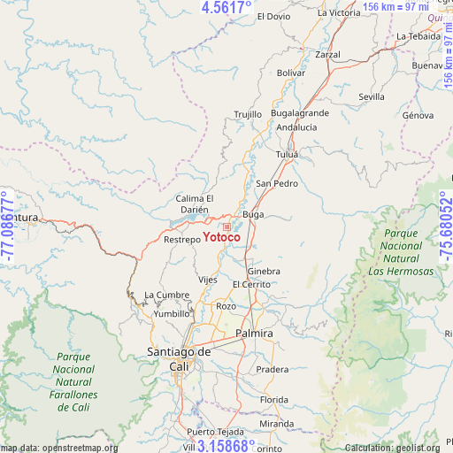
Yotoco GPS coordinates[2]
3° 51' 37.728" North, 76° 23' 1.104" West
| Map corner | latitude | longitude |
|---|---|---|
| Upper-left | 4.5617°, | -77.08677° |
| Center: | 3.86048°, | -76.38364° |
| Lower-right: | 3.15868°, | -75.68052° |
| Map W x H: | 156×156 km | = 96.9×96.9mi |
| max Lat: | 13.38166° ⇑79.2% North |
| Yotoco: | 3.86048° |
| min Lat: | ⇓20.8% South -4.21528° |
| min Long | Yotoco | max Long |
| -81.70636° | -76.38364° | -67.06996° |
| W 14.5%⇐ | ⇒85.5% E |
Elevation
Elevation of Yotoco is 956 m = 3136 ft, and this is 193.3 m = 634 ft below average elevation for this country.
| Max E: |
3342 m = 10965 ft | 56% |
| Avg. | 1149.3 m = 3771 ft | |
| Yotoco | 956 m = 3136 ft | |
Min E: |
1 m = 3 ft | 44% |
See also: Colombia elevation on elevation.city.
Geographical zone
Yotoco is located in North Torrid zone (between Equator and Tropic of Cancer). Distance of Equator is 429.2 km =266.7 mi to South.| Distance of | km | miles | from Yotoco |
|---|---|---|---|
| North Pole | 9577.8 | 5951.4 | to North |
| Arctic Circle | 6971.9 | 4332.1 | to North |
| Tropic Cancer | 2176.7 | 1352.5 | to North |
| Equator | 429.2 | 266.7 | to South |


Nearby cities:
15 places around Yotoco: (largest is in red/bold)
• Calimita
14.3 km =8.9 mi,  295°
295°
• Darien
13.7 km =8.5 mi,  305°
305°
• El Cerrito
20.9 km =13 mi,  158°
158°
• Ginebra
19.9 km =12.4 mi,  139°
139°
• Guacarí
12.1 km =7.5 mi,  152°
152°
• Guadalajara de Buga
10.5 km =6.5 mi,  64°
64°
• La Cumbre
31.2 km =19.4 mi,  221°
221°
• Palmira
36.8 km =22.9 mi,  166°
166°
• Restrepo
16 km =9.9 mi,  254°
254°
• Riofrío
34.6 km =21.5 mi,  17°
17°
• San Pedro
22.7 km =14.1 mi,  49°
49°
• Trujillo
39.7 km =24.7 mi,  10°
10°
• Tuluá
32.5 km =20.2 mi,  39°
39°
• Vijes
19.1 km =11.9 mi,  199°
199°
• Yumbo
33.2 km =20.6 mi, 201°
Sources, notices
• [Note1] Compared only with cities in Colombia existing in our database
• [Src1] Map data: © OpenStreetMap contributors (CC-BY-SA)
• [Src2] Other city data from geonames.org with taken over terms of usage.
• [Src3] Geographical zone / Annual Mean Temperature by Robert A. Rohde @ Wikipedia
