Ginebra geodata
Ginebra (Valle del Cauca) is a seat of a second-order administrative division; located in Colombia in America/Bogota (GMT-5) time zone. With population of 6,088 people, there are 446 cities with bigger population in this country. Compared to other cities in Colombia, 80% of cities are located further ↑North; 84% of cities are located further →East and 52.6% of cities have higher elevation than Ginebra. Note1


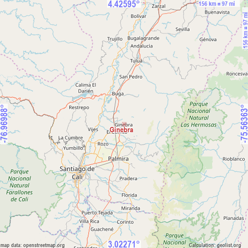
Ginebra GPS coordinates[2]
3° 43' 28.596" North, 76° 16' 0.3" West
| Map corner | latitude | longitude |
|---|---|---|
| Upper-left | 4.42595°, | -76.96988° |
| Center: | 3.72461°, | -76.26675° |
| Lower-right: | 3.02271°, | -75.56363° |
| Map W x H: | 156×156 km | = 96.9×96.9mi |
| max Lat: | 13.38166° ⇑80% North |
| Ginebra: | 3.72461° |
| min Lat: | ⇓20% South -4.21528° |
| min Long | Ginebra | max Long |
| -81.70636° | -76.26675° | -67.06996° |
| W 16%⇐ | ⇒84% E |
Elevation
Elevation of Ginebra is 1036 m = 3399 ft, and this is 113.3 m = 372 ft below average elevation for this country.
| Max E: |
3342 m = 10965 ft | 52.6% |
| Avg. | 1149.3 m = 3771 ft | |
| Ginebra | 1036 m = 3399 ft | |
Min E: |
1 m = 3 ft | 47.4% |
See also: Colombia elevation on elevation.city.
Geographical zone
Ginebra is located in North Torrid zone (between Equator and Tropic of Cancer). Distance of Equator is 414.1 km =257.3 mi to South.| Distance of | km | miles | from Ginebra |
|---|---|---|---|
| North Pole | 9592.9 | 5960.7 | to North |
| Arctic Circle | 6987 | 4341.5 | to North |
| Tropic Cancer | 2191.8 | 1361.9 | to North |
| Equator | 414.1 | 257.3 | to South |


Nearby cities:
15 places around Ginebra: (largest is in red/bold)
• Calimita
33.6 km =20.9 mi,  309°
309°
• Candelaria
36.5 km =22.7 mi,  194°
194°
• Darien
33.4 km =20.8 mi, 313°
• El Cerrito
6.8 km =4.2 mi,  230°
230°
• Guacarí
8.5 km =5.3 mi,  300°
300°
• Guadalajara de Buga
19.9 km =12.4 mi,  350°
350°
• La Cumbre
27.3 km =17 mi,  90°
90°
• La Cumbre
34.6 km =21.5 mi,  256°
256°
• Palmira
21 km =13 mi, 191°
• Pradera
33.8 km =21 mi,  175°
175°
• Restrepo
30.4 km =18.9 mi,  290°
290°
• San Pedro
30.3 km =18.8 mi,  7°
7°
• Vijes
19.7 km =12.2 mi, 261°
• Yotoco
19.9 km =12.4 mi,  319°
319°
• Yumbo
29.5 km =18.3 mi,  237°
237°
Sources, notices
• [Note1] Compared only with cities in Colombia existing in our database
• [Src1] Map data: © OpenStreetMap contributors (CC-BY-SA)
• [Src2] Other city data from geonames.org with taken over terms of usage.
• [Src3] Geographical zone / Annual Mean Temperature by Robert A. Rohde @ Wikipedia
