Corinto geodata
Corinto (Cauca) is a seat of a second-order administrative division; located in Colombia in America/Bogota (GMT-5) time zone. With population of 16,579 people, there are 209 cities with bigger population in this country. Compared to other cities in Colombia, 83.5% of cities are located further ↑North; 83.8% of cities are located further →East and 51.8% of cities have higher elevation than Corinto. Note1


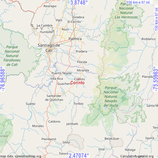
Corinto GPS coordinates[2]
3° 10' 22.836" North, 76° 15' 45.9" West
| Map corner | latitude | longitude |
|---|---|---|
| Upper-left | 3.8748°, | -76.96588° |
| Center: | 3.17301°, | -76.26275° |
| Lower-right: | 2.47074°, | -75.55963° |
| Map W x H: | 156.1×156.1 km | = 97×97mi |
| max Lat: | 13.38166° ⇑83.5% North |
| Corinto: | 3.17301° |
| min Lat: | ⇓16.5% South -4.21528° |
| min Long | Corinto | max Long |
| -81.70636° | -76.26275° | -67.06996° |
| W 16.2%⇐ | ⇒83.8% E |
Elevation
Elevation of Corinto is 1059 m = 3474 ft, and this is 90.3 m = 296 ft below average elevation for this country.
| Max E: |
3342 m = 10965 ft | 51.8% |
| Avg. | 1149.3 m = 3771 ft | |
| Corinto | 1059 m = 3474 ft | |
Min E: |
1 m = 3 ft | 48.2% |
See also: Colombia elevation on elevation.city.
Geographical zone
Corinto is located in North Torrid zone (between Equator and Tropic of Cancer). Distance of Equator is 352.8 km =219.2 mi to South.| Distance of | km | miles | from Corinto |
|---|---|---|---|
| North Pole | 9654.3 | 5998.9 | to North |
| Arctic Circle | 7048.4 | 4379.7 | to North |
| Tropic Cancer | 2253.1 | 1400 | to North |
| Equator | 352.8 | 219.2 | to South |


Nearby cities:
15 places around Corinto: (largest is in red/bold)
• Cali
41.2 km =25.6 mi,  315°
315°
• Caloto
22.2 km =13.8 mi,  226°
226°
• Candelaria
27.7 km =17.2 mi,  339°
339°
• Florida
16.9 km =10.5 mi,  10°
10°
• Guachené
15.1 km =9.4 mi,  252°
252°
• Jambaló
44.5 km =27.7 mi,  188°
188°
• Jamundí
31.8 km =19.8 mi,  287°
287°
• Miranda
9.6 km =6 mi,  22°
22°
• Padilla
7.7 km =4.8 mi,  312°
312°
• Palmira
41 km =25.5 mi,  353°
353°
• Pradera
27.7 km =17.2 mi,  4°
4°
• Puerto Tejada
18.3 km =11.4 mi, 290°
• Santander de Quilichao
30.6 km =19 mi, 233°
• Toribío
24.3 km =15.1 mi,  181°
181°
• Villa Rica
22.1 km =13.7 mi,  270°
270°
Sources, notices
• [Note1] Compared only with cities in Colombia existing in our database
• [Src1] Map data: © OpenStreetMap contributors (CC-BY-SA)
• [Src2] Other city data from geonames.org with taken over terms of usage.
• [Src3] Geographical zone / Annual Mean Temperature by Robert A. Rohde @ Wikipedia
