Caloto geodata
Caloto (Cauca) is a seat of a second-order administrative division; located in Colombia in America/Bogota (GMT-5) time zone. With population of 6,478 people, there are 424 cities with bigger population in this country. Compared to other cities in Colombia, 84% of cities are located further ↑North; 85.7% of cities are located further →East and 50.9% of cities have higher elevation than Caloto. Note1


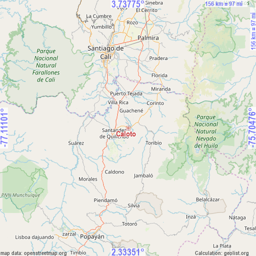
Caloto GPS coordinates[2]
3° 2' 9.096" North, 76° 24' 28.368" West
| Map corner | latitude | longitude |
|---|---|---|
| Upper-left | 3.73775°, | -77.11101° |
| Center: | 3.03586°, | -76.40788° |
| Lower-right: | 2.33351°, | -75.70476° |
| Map W x H: | 156.1×156.1 km | = 97×97mi |
| max Lat: | 13.38166° ⇑84% North |
| Caloto: | 3.03586° |
| min Lat: | ⇓16% South -4.21528° |
| min Long | Caloto | max Long |
| -81.70636° | -76.40788° | -67.06996° |
| W 14.3%⇐ | ⇒85.7% E |
Elevation
Elevation of Caloto is 1095 m = 3593 ft, and this is 54.3 m = 178 ft below average elevation for this country.
| Max E: |
3342 m = 10965 ft | 50.9% |
| Avg. | 1149.3 m = 3771 ft | |
| Caloto | 1095 m = 3593 ft | |
Min E: |
1 m = 3 ft | 49.1% |
See also: Colombia elevation on elevation.city.
Geographical zone
Caloto is located in North Torrid zone (between Equator and Tropic of Cancer). Distance of Equator is 337.6 km =209.8 mi to South.| Distance of | km | miles | from Caloto |
|---|---|---|---|
| North Pole | 9669.5 | 6008.3 | to North |
| Arctic Circle | 7063.6 | 4389.1 | to North |
| Tropic Cancer | 2268.4 | 1409.5 | to North |
| Equator | 337.6 | 209.8 | to South |


Nearby cities:
15 places around Caloto: (largest is in red/bold)
• Buenos Aires
26.6 km =16.5 mi,  264°
264°
• Caldono
27.8 km =17.3 mi,  197°
197°
• Corinto
22.2 km =13.8 mi,  46°
46°
• Florida
37.2 km =23.1 mi,  31°
31°
• Guachené
11 km =6.8 mi,  8°
8°
• Jambaló
30.2 km =18.8 mi,  162°
162°
• Jamundí
28.7 km =17.8 mi,  330°
330°
• Miranda
31.2 km =19.4 mi,  39°
39°
• Morales
39.7 km =24.7 mi,  217°
217°
• Padilla
23 km =14.3 mi, 26°
• Puerto Tejada
21.7 km =13.5 mi,  357°
357°
• Santander de Quilichao
9 km =5.6 mi,  251°
251°
• Suárez
33.3 km =20.7 mi, 254°
• Toribío
17.9 km =11.1 mi,  120°
120°
• Villa Rica
16.6 km =10.3 mi,  338°
338°
Sources, notices
• [Note1] Compared only with cities in Colombia existing in our database
• [Src1] Map data: © OpenStreetMap contributors (CC-BY-SA)
• [Src2] Other city data from geonames.org with taken over terms of usage.
• [Src3] Geographical zone / Annual Mean Temperature by Robert A. Rohde @ Wikipedia
