Buenos Aires geodata
Buenos Aires (Cauca) is a populated place; located in Colombia in America/Bogota (GMT-5) time zone. With population of 2,144 people, there are 779 cities with bigger population in this country. Compared to other cities in Colombia, 84.2% of cities are located further ↑North; 89% of cities are located further →East and 52% of cities have lower elevation than Buenos Aires. Note1


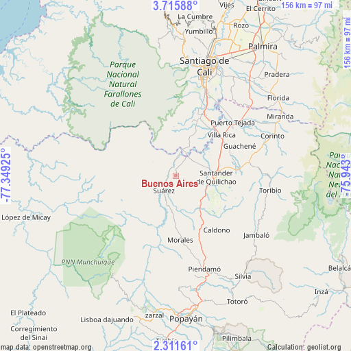
Buenos Aires GPS coordinates[2]
3° 0' 50.292" North, 76° 38' 46.032" West
| Map corner | latitude | longitude |
|---|---|---|
| Upper-left | 3.71588°, | -77.34925° |
| Center: | 3.01397°, | -76.64612° |
| Lower-right: | 2.31161°, | -75.943° |
| Map W x H: | 156.1×156.1 km | = 97×97mi |
| max Lat: | 13.38166° ⇑84.2% North |
| Buenos Aires: | 3.01397° |
| min Lat: | ⇓15.8% South -4.21528° |
| min Long | Buenos Aires | max Long |
| -81.70636° | -76.64612° | -67.06996° |
| W 11%⇐ | ⇒89% E |
Elevation
Elevation of Buenos Aires is 1200 m = 3937 ft, and this is 50.7 m = 166 ft above average elevation for this country.
| Max E: |
3342 m = 10965 ft | 48% |
| Buenos Aires | 1200 m 3937 ft | |
| Avg. | 1149.3 m = 3771 ft | |
Min E: |
1 m = 3 ft | 52% |
See also: Colombia elevation on elevation.city.
Geographical zone
Buenos Aires is located in North Torrid zone (between Equator and Tropic of Cancer). Distance of Equator is 335.1 km =208.2 mi to South.| Distance of | km | miles | from Buenos Aires |
|---|---|---|---|
| North Pole | 9671.9 | 6009.8 | to North |
| Arctic Circle | 7066.1 | 4390.7 | to North |
| Tropic Cancer | 2270.8 | 1411 | to North |
| Equator | 335.1 | 208.2 | to South |


Nearby cities:
15 places around Buenos Aires: (largest is in red/bold)
• Cajibío
44.3 km =27.5 mi,  169°
169°
• Caldono
30.1 km =18.7 mi,  143°
143°
• Caloto
26.6 km =16.5 mi,  84°
84°
• Corinto
46.1 km =28.6 mi,  67°
67°
• Guachené
31.1 km =19.3 mi,  64°
64°
• Jambaló
44.3 km =27.5 mi,  126°
126°
• Jamundí
30.1 km =18.7 mi,  24°
24°
• Morales
28.9 km =18 mi,  175°
175°
• Padilla
43.4 km =27 mi, 58°
• Piendamo
43.6 km =27.1 mi,  162°
162°
• Puerto Tejada
35.1 km =21.8 mi,  46°
46°
• Santander de Quilichao
17.9 km =11.1 mi,  91°
91°
• Suárez
8.7 km =5.4 mi,  219°
219°
• Toribío
42.5 km =26.4 mi,  98°
98°
• Villa Rica
27.2 km =16.9 mi, 48°
Sources, notices
• [Note1] Compared only with cities in Colombia existing in our database
• [Src1] Map data: © OpenStreetMap contributors (CC-BY-SA)
• [Src2] Other city data from geonames.org with taken over terms of usage.
• [Src3] Geographical zone / Annual Mean Temperature by Robert A. Rohde @ Wikipedia
