Buenavista geodata
Buenavista (Magdalena) is a populated place; located in Colombia in America/Bogota (GMT-5) time zone. With population of 4,339 people, there are 552 cities with bigger population in this country. Compared to other cities in Colombia, 88.3% of cities are located further ↓South; 60.1% of cities are located further ←West and 91.5% of cities have higher elevation than Buenavista. Note1


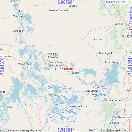
Buenavista GPS coordinates[2]
9° 12' 51.588" North, 74° 18' 49.068" West
| Map corner | latitude | longitude |
|---|---|---|
| Upper-left | 9.90768°, | -75.01676° |
| Center: | 9.21433°, | -74.31363° |
| Lower-right: | 8.51961°, | -73.61051° |
| Map W x H: | 154.3×154.3 km | = 95.9×95.9mi |
| max Lat: | 13.38166° ⇑11.7% North |
| Buenavista: | 9.21433° |
| min Lat: | ⇓88.3% South -4.21528° |
| min Long | Buenavista | max Long |
| -81.70636° | -74.31363° | -67.06996° |
| W 60.1%⇐ | ⇒39.9% E |
Elevation
Elevation of Buenavista is 24 m = 79 ft, and this is 1125.3 m = 3692 ft below average elevation for this country.
| Max E: |
3342 m = 10965 ft | 91.5% |
| Avg. | 1149.3 m = 3771 ft | |
| Buenavista | 24 m = 79 ft | |
Min E: |
1 m = 3 ft | 8.5% |
See also: Colombia elevation on elevation.city.
Geographical zone
Buenavista is located in North Torrid zone (between Equator and Tropic of Cancer). Distance of Equator is 1024.5 km =636.6 mi to South.| Distance of | km | miles | from Buenavista |
|---|---|---|---|
| North Pole | 8982.5 | 5581.5 | to North |
| Arctic Circle | 6376.6 | 3962.2 | to North |
| Tropic Cancer | 1581.4 | 982.6 | to North |
| Equator | 1024.5 | 636.6 | to South |


Nearby cities:
15 places around Buenavista: (largest is in red/bold)
• Barranco de Loba
37.5 km =23.3 mi,  142°
142°
• Cicuco
36.8 km =22.9 mi,  281°
281°
• Guamal
12.6 km =7.8 mi,  128°
128°
• Hatillo de Loba
38.6 km =24 mi, 137°
• Margarita
8.3 km =5.2 mi, 141°
• Mompós
12.8 km =8 mi, 283°
• Pijiño del Carmen
19.9 km =12.4 mi,  309°
309°
• Pinillos
36.9 km =22.9 mi,  207°
207°
• San Fernando
0.6 km =0.4 mi,  231°
231°
• San Fernando
25.2 km =15.7 mi,  286°
286°
• San Sebastián de Buenavista
4.9 km =3 mi,  301°
301°
• San Zenón
20.7 km =12.9 mi, 278°
• Santa Ana
30.4 km =18.9 mi, 293°
• Talaigua Nuevo
29.3 km =18.2 mi, 289°
• Talaigua Viejo
31.7 km =19.7 mi, 290°
Sources, notices
• [Note1] Compared only with cities in Colombia existing in our database
• [Src1] Map data: © OpenStreetMap contributors (CC-BY-SA)
• [Src2] Other city data from geonames.org with taken over terms of usage.
• [Src3] Geographical zone / Annual Mean Temperature by Robert A. Rohde @ Wikipedia
