Algarrobo geodata
Algarrobo (Magdalena) is a populated place; located in Colombia in America/Bogota (GMT-5) time zone. With population of 10,042 people, there are 303 cities with bigger population in this country. Compared to other cities in Colombia, 93.6% of cities are located further ↓South; 55.3% of cities are located further ←West and 86% of cities have higher elevation than Algarrobo. Note1


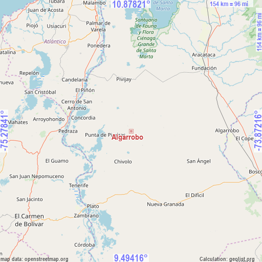
Algarrobo GPS coordinates[2]
10° 11' 12.984" North, 74° 34' 31.008" West
| Map corner | latitude | longitude |
|---|---|---|
| Upper-left | 10.87821°, | -75.27841° |
| Center: | 10.18694°, | -74.57528° |
| Lower-right: | 9.49416°, | -73.87216° |
| Map W x H: | 153.9×153.9 km | = 95.6×95.6mi |
| max Lat: | 13.38166° ⇑6.4% North |
| Algarrobo: | 10.18694° |
| min Lat: | ⇓93.6% South -4.21528° |
| min Long | Algarrobo | max Long |
| -81.70636° | -74.57528° | -67.06996° |
| W 55.3%⇐ | ⇒44.7% E |
Elevation
Elevation of Algarrobo is 51 m = 167 ft, and this is 1098.3 m = 3603 ft below average elevation for this country.
| Max E: |
3342 m = 10965 ft | 86% |
| Avg. | 1149.3 m = 3771 ft | |
| Algarrobo | 51 m = 167 ft | |
Min E: |
1 m = 3 ft | 14% |
See also: Colombia elevation on elevation.city.
Geographical zone
Algarrobo is located in North Torrid zone (between Equator and Tropic of Cancer). Distance of Equator is 1132.7 km =703.8 mi to South.| Distance of | km | miles | from Algarrobo |
|---|---|---|---|
| North Pole | 8874.4 | 5514.3 | to North |
| Arctic Circle | 6268.5 | 3895.1 | to North |
| Tropic Cancer | 1473.2 | 915.4 | to North |
| Equator | 1132.7 | 703.8 | to South |


Nearby cities:
15 places around Algarrobo: (largest is in red/bold)
• Calamar
38 km =23.6 mi,  281°
281°
• Campo de la Cruz
39.9 km =24.8 mi,  302°
302°
• Cerro de San Antonio
35.7 km =22.2 mi, 295°
• Chivolo
18.7 km =11.6 mi,  196°
196°
• Concordia
29.3 km =18.2 mi,  285°
285°
• Concordia
41.2 km =25.6 mi,  161°
161°
• El Piñón
36.3 km =22.6 mi,  311°
311°
• Pedraza
37.2 km =23.1 mi,  270°
270°
• Pivijay
30.9 km =19.2 mi,  351°
351°
• Punta de Piedras
15.6 km =9.7 mi,  262°
262°
• Salamina
41.4 km =25.7 mi,  324°
324°
• San Antonio
31.1 km =19.3 mi, 204°
• San Ángel
43.1 km =26.8 mi,  113°
113°
• Suan
37.1 km =23.1 mi, 296°
• Tenerife
44.5 km =27.7 mi,  224°
224°
Sources, notices
• [Note1] Compared only with cities in Colombia existing in our database
• [Src1] Map data: © OpenStreetMap contributors (CC-BY-SA)
• [Src2] Other city data from geonames.org with taken over terms of usage.
• [Src3] Geographical zone / Annual Mean Temperature by Robert A. Rohde @ Wikipedia
