San Antonio geodata
San Antonio (Magdalena) is a populated place; located in Colombia in America/Bogota (GMT-5) time zone. With population of 8,476 people, there are 352 cities with bigger population in this country. Compared to other cities in Colombia, 92.6% of cities are located further ↓South; 53.6% of cities are located further ←West and 80.5% of cities have higher elevation than San Antonio. Note1


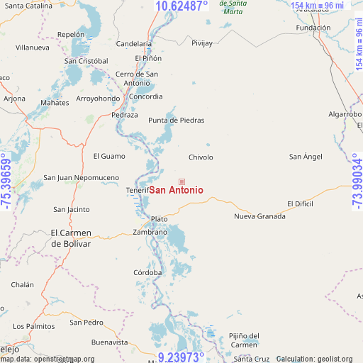
San Antonio GPS coordinates[2]
9° 55' 58.908" North, 74° 41' 36.456" West
| Map corner | latitude | longitude |
|---|---|---|
| Upper-left | 10.62487°, | -75.39659° |
| Center: | 9.93303°, | -74.69346° |
| Lower-right: | 9.23973°, | -73.99034° |
| Map W x H: | 154×154 km | = 95.7×95.7mi |
| max Lat: | 13.38166° ⇑7.4% North |
| San Antonio: | 9.93303° |
| min Lat: | ⇓92.6% South -4.21528° |
| min Long | San Antonio | max Long |
| -81.70636° | -74.69346° | -67.06996° |
| W 53.6%⇐ | ⇒46.4% E |
Elevation
Elevation of San Antonio is 110 m = 361 ft, and this is 1039.3 m = 3410 ft below average elevation for this country.
| Max E: |
3342 m = 10965 ft | 80.5% |
| Avg. | 1149.3 m = 3771 ft | |
| San Antonio | 110 m = 361 ft | |
Min E: |
1 m = 3 ft | 19.5% |
See also: Colombia elevation on elevation.city.
Geographical zone
San Antonio is located in North Torrid zone (between Equator and Tropic of Cancer). Distance of Equator is 1104.4 km =686.2 mi to South.| Distance of | km | miles | from San Antonio |
|---|---|---|---|
| North Pole | 8902.6 | 5531.8 | to North |
| Arctic Circle | 6296.7 | 3912.6 | to North |
| Tropic Cancer | 1501.5 | 933 | to North |
| Equator | 1104.4 | 686.2 | to South |


Nearby cities:
15 places around San Antonio: (largest is in red/bold)
• Algarrobo
31.1 km =19.3 mi,  24°
24°
• Calamar
43.1 km =26.8 mi,  325°
325°
• Cerro de San Antonio
47.7 km =29.6 mi,  336°
336°
• Chivolo
12.8 km =8 mi,  37°
37°
• Concordia
28.2 km =17.5 mi,  112°
112°
• Concordia
39.2 km =24.4 mi, 337°
• Córdoba
41.3 km =25.7 mi,  200°
200°
• El Guamo
32.8 km =20.4 mi,  289°
289°
• Nueva Granada
36 km =22.4 mi, 113°
• Pedraza
37.3 km =23.2 mi,  319°
319°
• Plato
18.6 km =11.6 mi,  211°
211°
• Punta de Piedras
26.3 km =16.3 mi,  354°
354°
• San Juan Nepomuceno
42.6 km =26.5 mi,  272°
272°
• Tenerife
18.6 km =11.6 mi,  258°
258°
• Zambrano
24.6 km =15.3 mi, 212°
Sources, notices
• [Note1] Compared only with cities in Colombia existing in our database
• [Src1] Map data: © OpenStreetMap contributors (CC-BY-SA)
• [Src2] Other city data from geonames.org with taken over terms of usage.
• [Src3] Geographical zone / Annual Mean Temperature by Robert A. Rohde @ Wikipedia
