Quivicán geodata
Quivicán (Mayabeque) is a seat of a second-order administrative division; located in Cuba in America/Havana (GMT-4) time zone. With population of 12,919 people, there are 133 cities with bigger population in this country. Compared to other cities in Cuba, 80.1% of cities are located further ↓South; 80.7% of cities are located further →East and 51.4% of cities have higher elevation than Quivicán. Note1


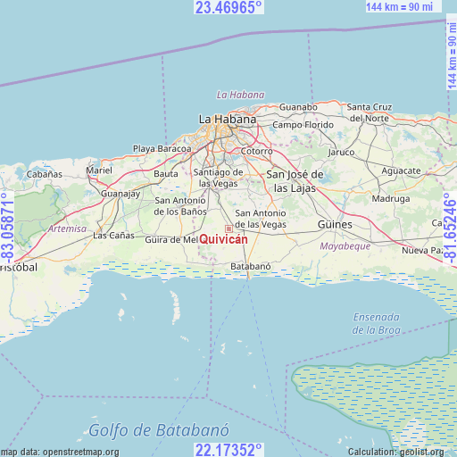
Quivicán GPS coordinates[2]
22° 49' 23.268" North, 82° 21' 20.088" West
| Map corner | latitude | longitude |
|---|---|---|
| Upper-left | 23.46965°, | -83.05871° |
| Center: | 22.82313°, | -82.35558° |
| Lower-right: | 22.17352°, | -81.65246° |
| Map W x H: | 144.1×144.1 km | = 89.5×89.5mi |
| max Lat: | 23.15917° ⇑19.9% North |
| Quivicán: | 22.82313° |
| min Lat: | ⇓80.1% South 19.90553° |
| min Long | Quivicán | max Long |
| -84.28599° | -82.35558° | -74.15181° |
| W 19.3%⇐ | ⇒80.7% E |
Elevation
Elevation of Quivicán is 51 m = 167 ft, and this is 17.6 m = 58 ft below average elevation for this country.
| Max E: |
761 m = 2497 ft | 51.4% |
| Avg. | 68.6 m = 225 ft | |
| Quivicán | 51 m = 167 ft | |
Min E: |
3 m = 10 ft | 48.6% |
See also: Cuba elevation on elevation.city.
Geographical zone
Quivicán is located in North Torrid zone (between Equator and Tropic of Cancer). Distance of this Northern Tropic circle is 68.2 km =42.4 mi to North.| Distance of | km | miles | from Quivicán |
|---|---|---|---|
| North Pole | 7469.4 | 4641.3 | to North |
| Arctic Circle | 4863.5 | 3022 | to North |
| Tropic Cancer | 68.2 | 42.4 | to North |
| Equator | 2537.7 | 1576.9 | to South |


Nearby cities:
15 places around Quivicán: (largest is in red/bold)
• Alquízar
23.5 km =14.6 mi,  265°
265°
• Arroyo Naranjo
23.8 km =14.8 mi,  356°
356°
• Batabanó
13.5 km =8.4 mi,  149°
149°
• Bauta
26.4 km =16.4 mi,  312°
312°
• Bejucal
12.2 km =7.6 mi,  343°
343°
• Boyeros
21 km =13 mi,  347°
347°
• Guara
15.7 km =9.8 mi,  95°
95°
• Güira de Melena
15.8 km =9.8 mi,  259°
259°
• Jamaica
25.6 km =15.9 mi,  48°
48°
• La Salud
8.8 km =5.5 mi, 308°
• Mañalich
21.4 km =13.3 mi,  93°
93°
• Melena del Sur
21.3 km =13.2 mi, 100°
• San Antonio de los Baños
16.7 km =10.4 mi,  296°
296°
• San José de las Lajas
26 km =16.2 mi, 53°
• Santiago de las Vegas
16.6 km =10.3 mi, 348°
Sources, notices
• [Note1] Compared only with cities in Cuba existing in our database
• [Src1] Map data: © OpenStreetMap contributors (CC-BY-SA)
• [Src2] Other city data from geonames.org with taken over terms of usage.
• [Src3] Geographical zone / Annual Mean Temperature by Robert A. Rohde @ Wikipedia
